You are here: Home > Network List > TA - USArray Transportable Network (new EarthScope stations) Stations List
> Station J20A Shoshoni, WY, USA > Earthquake Result Viewer
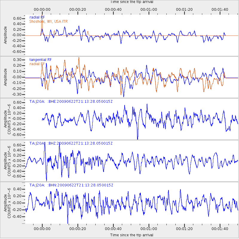
J20A Shoshoni, WY, USA - Earthquake Result Viewer
*The percent match for this event was below the threshold and hence no stack was calculated.
| Earthquake location: |
Andreanof Islands, Aleutian Is. |
| Earthquake latitude/longitude: |
51.3/-178.2 |
| Earthquake time(UTC): |
2009/06/22 (173) 21:05:33 GMT |
| Earthquake Depth: |
29 km |
| Earthquake Magnitude: |
5.5 MB, 5.0 MS, 5.4 MW, 5.4 MW |
| Earthquake Catalog/Contributor: |
WHDF/NEIC |
|
| Network: |
TA USArray Transportable Network (new EarthScope stations) |
| Station: |
J20A Shoshoni, WY, USA |
| Lat/Lon: |
43.35 N/108.08 W |
| Elevation: |
1500 m |
|
| Distance: |
46.5 deg |
| Az: |
71.002 deg |
| Baz: |
305.612 deg |
| Ray Param: |
$rayparam |
*The percent match for this event was below the threshold and hence was not used in the summary stack. |
|
| Radial Match: |
59.768654 % |
| Radial Bump: |
400 |
| Transverse Match: |
53.980976 % |
| Transverse Bump: |
400 |
| SOD ConfigId: |
2648 |
| Insert Time: |
2010-03-06 11:13:16.549 +0000 |
| GWidth: |
2.5 |
| Max Bumps: |
400 |
| Tol: |
0.001 |
|
Signal To Noise
| Channel | StoN | STA | LTA |
| TA:J20A: :BHZ:20090622T21:13:28.050015Z | 2.5355675 | 2.9937843E-7 | 1.1807157E-7 |
| TA:J20A: :BHN:20090622T21:13:28.050015Z | 1.0000025 | 1.2301757E-7 | 1.2301727E-7 |
| TA:J20A: :BHE:20090622T21:13:28.050015Z | 1.2090477 | 1.5592347E-7 | 1.2896389E-7 |
| Arrivals |
| Ps | |
| PpPs | |
| PsPs/PpSs | |


