You are here: Home > Network List > GS - US Geological Survey Networks Stations List
> Station OK043 N2390 and E0400 Rds, Waynoka, OK, USA > Earthquake Result Viewer
OK043 N2390 and E0400 Rds, Waynoka, OK, USA - Earthquake Result Viewer
| Earthquake location: |
Near Coast Of Ecuador |
| Earthquake latitude/longitude: |
0.5/-79.6 |
| Earthquake time(UTC): |
2016/05/18 (139) 16:46:44 GMT |
| Earthquake Depth: |
31 km |
| Earthquake Magnitude: |
6.8 MO |
| Earthquake Catalog/Contributor: |
NEIC PDE/NEIC ALERT |
|
| Network: |
GS US Geological Survey Networks |
| Station: |
OK043 N2390 and E0400 Rds, Waynoka, OK, USA |
| Lat/Lon: |
36.43 N/98.75 W |
| Elevation: |
406 m |
|
| Distance: |
39.9 deg |
| Az: |
335.72 deg |
| Baz: |
149.345 deg |
| Ray Param: |
0.07462936 |
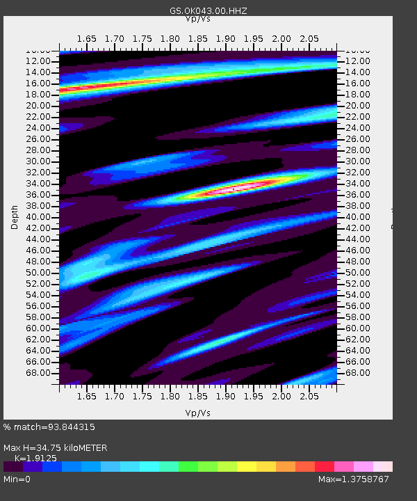
| Estimated Moho Depth: |
34.75 km |
| Estimated Crust Vp/Vs: |
1.91 |
| Assumed Crust Vp: |
6.426 km/s |
| Estimated Crust Vs: |
3.36 km/s |
| Estimated Crust Poisson's Ratio: |
0.31 |
|
| Radial Match: |
93.844315 % |
| Radial Bump: |
400 |
| Transverse Match: |
72.212944 % |
| Transverse Bump: |
400 |
| SOD ConfigId: |
1475611 |
| Insert Time: |
2016-06-01 16:50:46.432 +0000 |
| GWidth: |
2.5 |
| Max Bumps: |
400 |
| Tol: |
0.001 |
|

Signal To Noise
| Channel | StoN | STA | LTA |
| GS:OK043:00:HHZ:20160518T16:53:44.80899Z | 8.355916 | 1.530618E-6 | 1.8317776E-7 |
| GS:OK043:00:HH1:20160518T16:53:44.80899Z | 2.0666978 | 7.0512476E-7 | 3.4118426E-7 |
| GS:OK043:00:HH2:20160518T16:53:44.80899Z | 2.0516965 | 7.82696E-7 | 3.8148724E-7 |
| Arrivals |
| Ps | 5.3 SECOND |
| PpPs | 15 SECOND |
| PsPs/PpSs | 20 SECOND |


