You are here: Home > Network List > II - Global Seismograph Network (GSN - IRIS/IDA) Stations List
> Station CMLA Cha de Macela, Sao Miguel Island, Azores > Earthquake Result Viewer
CMLA Cha de Macela, Sao Miguel Island, Azores - Earthquake Result Viewer
| Earthquake location: |
Near Coast Of Ecuador |
| Earthquake latitude/longitude: |
0.5/-79.6 |
| Earthquake time(UTC): |
2016/05/18 (139) 16:46:44 GMT |
| Earthquake Depth: |
31 km |
| Earthquake Magnitude: |
6.8 MO |
| Earthquake Catalog/Contributor: |
NEIC PDE/NEIC ALERT |
|
| Network: |
II Global Seismograph Network (GSN - IRIS/IDA) |
| Station: |
CMLA Cha de Macela, Sao Miguel Island, Azores |
| Lat/Lon: |
37.76 N/25.52 W |
| Elevation: |
429 m |
|
| Distance: |
62.0 deg |
| Az: |
46.654 deg |
| Baz: |
246.573 deg |
| Ray Param: |
0.0604641 |
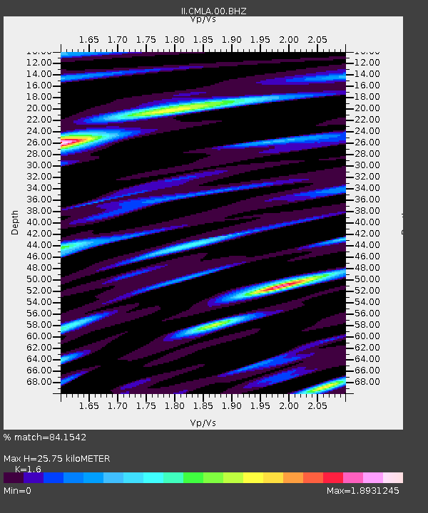
| Estimated Moho Depth: |
25.75 km |
| Estimated Crust Vp/Vs: |
1.60 |
| Assumed Crust Vp: |
4.802 km/s |
| Estimated Crust Vs: |
3.001 km/s |
| Estimated Crust Poisson's Ratio: |
0.18 |
|
| Radial Match: |
84.1542 % |
| Radial Bump: |
400 |
| Transverse Match: |
60.06158 % |
| Transverse Bump: |
400 |
| SOD ConfigId: |
1475611 |
| Insert Time: |
2016-06-01 16:51:09.339 +0000 |
| GWidth: |
2.5 |
| Max Bumps: |
400 |
| Tol: |
0.001 |
|
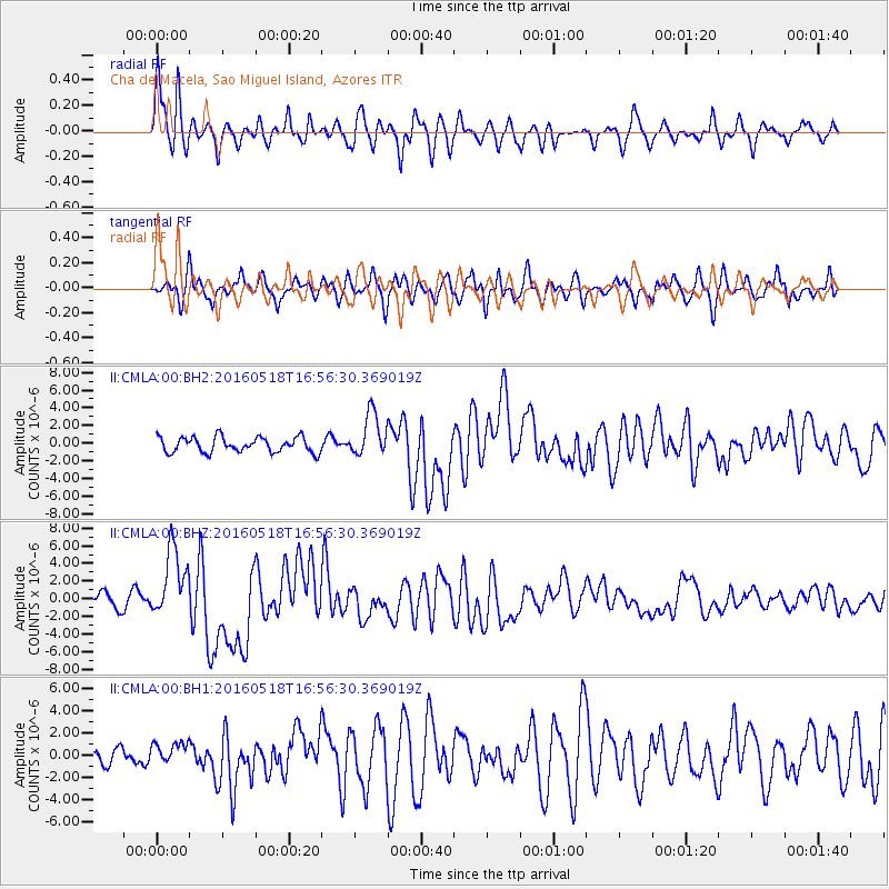
Signal To Noise
| Channel | StoN | STA | LTA |
| II:CMLA:00:BHZ:20160518T16:56:30.369019Z | 5.541697 | 3.9527263E-6 | 7.1327E-7 |
| II:CMLA:00:BH1:20160518T16:56:30.369019Z | 0.67704314 | 9.75888E-7 | 1.4413972E-6 |
| II:CMLA:00:BH2:20160518T16:56:30.369019Z | 2.8675616 | 2.4613325E-6 | 8.583364E-7 |
| Arrivals |
| Ps | 3.3 SECOND |
| PpPs | 14 SECOND |
| PsPs/PpSs | 17 SECOND |


