You are here: Home > Network List > KZ - Kazakhstan Network Stations List
> Station ABKAR Akbulak array,AB31, Kazakhstan > Earthquake Result Viewer
ABKAR Akbulak array,AB31, Kazakhstan - Earthquake Result Viewer
| Earthquake location: |
Hokkaido, Japan Region |
| Earthquake latitude/longitude: |
42.7/145.6 |
| Earthquake time(UTC): |
2018/05/17 (137) 18:42:10 GMT |
| Earthquake Depth: |
10 km |
| Earthquake Magnitude: |
5.8 Mww |
| Earthquake Catalog/Contributor: |
NEIC PDE/us |
|
| Network: |
KZ Kazakhstan Network |
| Station: |
ABKAR Akbulak array,AB31, Kazakhstan |
| Lat/Lon: |
49.26 N/59.94 E |
| Elevation: |
362 m |
|
| Distance: |
56.9 deg |
| Az: |
308.712 deg |
| Baz: |
61.435 deg |
| Ray Param: |
0.06387024 |
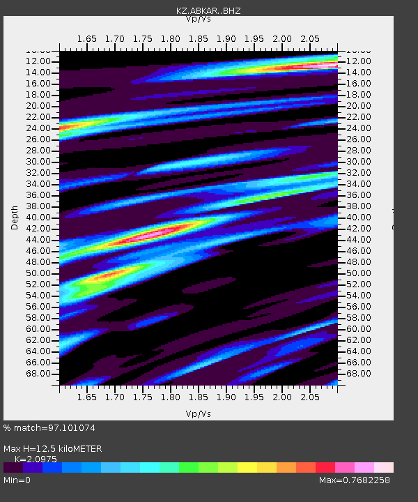
| Estimated Moho Depth: |
12.5 km |
| Estimated Crust Vp/Vs: |
2.10 |
| Assumed Crust Vp: |
6.35 km/s |
| Estimated Crust Vs: |
3.027 km/s |
| Estimated Crust Poisson's Ratio: |
0.35 |
|
| Radial Match: |
97.101074 % |
| Radial Bump: |
400 |
| Transverse Match: |
91.504814 % |
| Transverse Bump: |
400 |
| SOD ConfigId: |
13570011 |
| Insert Time: |
2019-04-30 06:33:23.343 +0000 |
| GWidth: |
2.5 |
| Max Bumps: |
400 |
| Tol: |
0.001 |
|

Signal To Noise
| Channel | StoN | STA | LTA |
| KZ:ABKAR: :BHZ:20180517T18:51:23.924995Z | 58.917652 | 4.3206137E-6 | 7.333309E-8 |
| KZ:ABKAR: :BHN:20180517T18:51:23.924995Z | 19.766617 | 8.626766E-7 | 4.3643105E-8 |
| KZ:ABKAR: :BHE:20180517T18:51:23.924995Z | 59.68327 | 2.6803389E-6 | 4.490938E-8 |
| Arrivals |
| Ps | 2.3 SECOND |
| PpPs | 5.9 SECOND |
| PsPs/PpSs | 8.1 SECOND |


