You are here: Home > Network List > TA - USArray Transportable Network (new EarthScope stations) Stations List
> Station O22A Kremmling, CO, USA > Earthquake Result Viewer
O22A Kremmling, CO, USA - Earthquake Result Viewer
| Earthquake location: |
Dodecanese Islands, Greece |
| Earthquake latitude/longitude: |
35.8/27.9 |
| Earthquake time(UTC): |
2008/07/15 (197) 03:26:34 GMT |
| Earthquake Depth: |
52 km |
| Earthquake Magnitude: |
6.5 MB, 6.4 MW, 6.4 MW |
| Earthquake Catalog/Contributor: |
WHDF/NEIC |
|
| Network: |
TA USArray Transportable Network (new EarthScope stations) |
| Station: |
O22A Kremmling, CO, USA |
| Lat/Lon: |
40.16 N/106.55 W |
| Elevation: |
2747 m |
|
| Distance: |
93.5 deg |
| Az: |
326.734 deg |
| Baz: |
35.581 deg |
| Ray Param: |
0.041217156 |
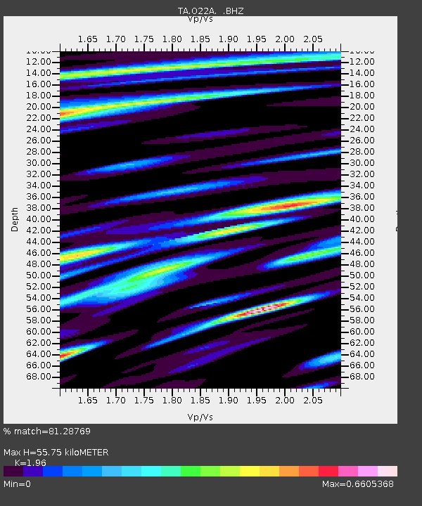
| Estimated Moho Depth: |
55.75 km |
| Estimated Crust Vp/Vs: |
1.96 |
| Assumed Crust Vp: |
6.159 km/s |
| Estimated Crust Vs: |
3.142 km/s |
| Estimated Crust Poisson's Ratio: |
0.32 |
|
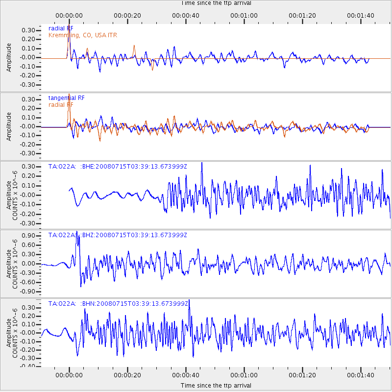
| Radial Match: |
81.28769 % |
| Radial Bump: |
400 |
| Transverse Match: |
67.02402 % |
| Transverse Bump: |
400 |
| SOD ConfigId: |
2504 |
| Insert Time: |
2010-03-06 11:14:10.615 +0000 |
| GWidth: |
2.5 |
| Max Bumps: |
400 |
| Tol: |
0.001 |
|
Signal To Noise
| Channel | StoN | STA | LTA |
| TA:O22A: :BHZ:20080715T03:39:13.673999Z | 11.41039 | 4.6481262E-7 | 4.073591E-8 |
| TA:O22A: :BHN:20080715T03:39:13.673999Z | 3.7887874 | 1.1105166E-7 | 2.9310607E-8 |
| TA:O22A: :BHE:20080715T03:39:13.673999Z | 2.3275132 | 8.653932E-8 | 3.7181024E-8 |
| Arrivals |
| Ps | 8.8 SECOND |
| PpPs | 26 SECOND |
| PsPs/PpSs | 35 SECOND |


