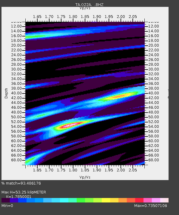
O22A Kremmling, CO, USA - Earthquake Result Viewer
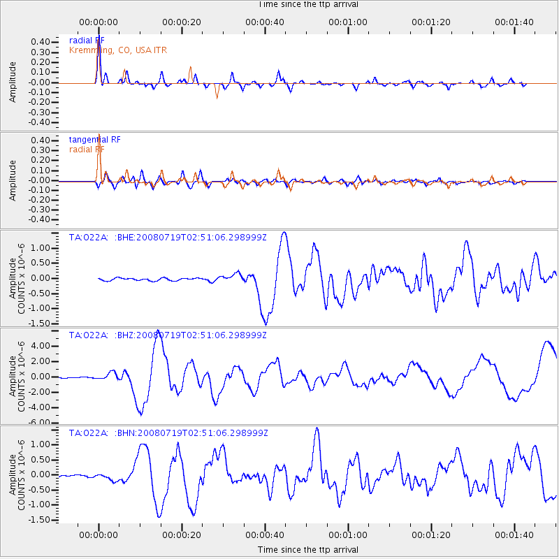
Earthquake location: Off East Coast Of Honshu, Japan
Earthquake latitude/longitude: 37.6/142.2
Earthquake time(UTC): 2008/07/19 (201) 02:39:28 GMT
Earthquake Depth: 22 km
Earthquake Magnitude: 6.2 MB, 7.0 MS, 7.0 MW, 6.9 MW
Earthquake Catalog/Contributor: WHDF/NEIC
Network: TA USArray Transportable Network (new EarthScope stations)
Station: O22A Kremmling, CO, USA
Lat/Lon: 40.16 N/106.55 W
Elevation: 2747 m
Distance: 80.3 deg
Az: 46.449 deg
Baz: 311.268 deg
Ray Param: 0.048378527
Estimated Moho Depth: 53.25 km
Estimated Crust Vp/Vs: 1.79
Assumed Crust Vp: 6.159 km/s
Estimated Crust Vs: 3.45 km/s
Estimated Crust Poisson's Ratio: 0.27
Radial Match: 93.486176 %
Radial Bump: 386
Transverse Match: 80.07906 %
Transverse Bump: 400
SOD ConfigId: 2504
Insert Time: 2010-03-06 11:14:14.317 +0000
GWidth: 2.5
Max Bumps: 400
Tol: 0.001

Signal To Noise

ChannelStoNSTALTA
TA:O22A: :BHZ:20080719T02:51:06.298999Z9.2337454.930453E-75.339603E-8
TA:O22A: :BHN:20080719T02:51:06.298999Z3.45086221.2155103E-73.522338E-8
TA:O22A: :BHE:20080719T02:51:06.298999Z3.3529681.398678E-74.171462E-8
Arrivals
Ps7.0 SECOND
PpPs23 SECOND
PsPs/PpSs30 SECOND