You are here: Home > Network List > TA - USArray Transportable Network (new EarthScope stations) Stations List
> Station O22A Kremmling, CO, USA > Earthquake Result Viewer
O22A Kremmling, CO, USA - Earthquake Result Viewer
| Earthquake location: |
Santa Cruz Islands Region |
| Earthquake latitude/longitude: |
-11.0/164.5 |
| Earthquake time(UTC): |
2008/07/19 (201) 09:27:01 GMT |
| Earthquake Depth: |
11 km |
| Earthquake Magnitude: |
6.1 MB, 6.4 MS, 6.6 MW, 6.6 MW |
| Earthquake Catalog/Contributor: |
WHDF/NEIC |
|
| Network: |
TA USArray Transportable Network (new EarthScope stations) |
| Station: |
O22A Kremmling, CO, USA |
| Lat/Lon: |
40.16 N/106.55 W |
| Elevation: |
2747 m |
|
| Distance: |
96.2 deg |
| Az: |
50.425 deg |
| Baz: |
260.897 deg |
| Ray Param: |
0.040570498 |
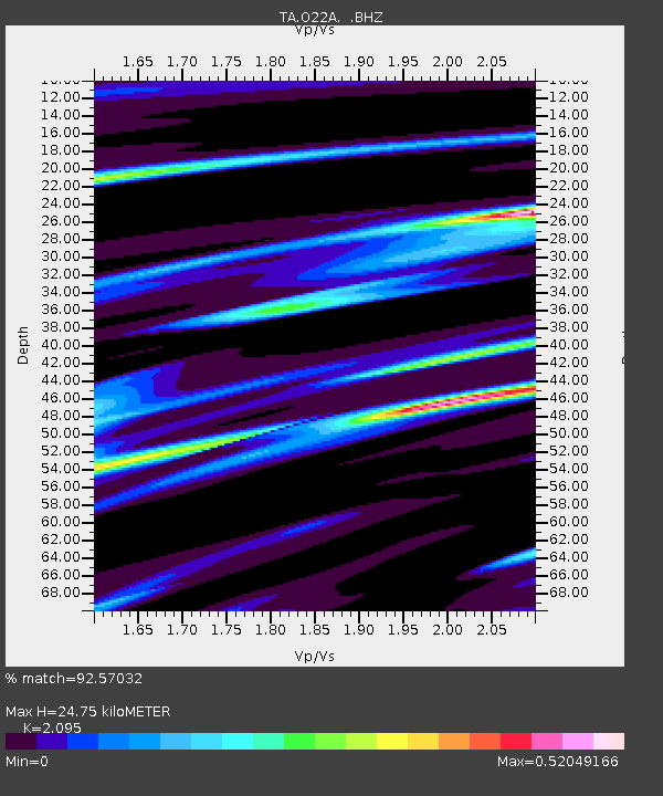
| Estimated Moho Depth: |
24.75 km |
| Estimated Crust Vp/Vs: |
2.10 |
| Assumed Crust Vp: |
6.159 km/s |
| Estimated Crust Vs: |
2.94 km/s |
| Estimated Crust Poisson's Ratio: |
0.35 |
|
| Radial Match: |
92.57032 % |
| Radial Bump: |
287 |
| Transverse Match: |
75.84779 % |
| Transverse Bump: |
400 |
| SOD ConfigId: |
2658 |
| Insert Time: |
2010-03-06 11:14:51.996 +0000 |
| GWidth: |
2.5 |
| Max Bumps: |
400 |
| Tol: |
0.001 |
|
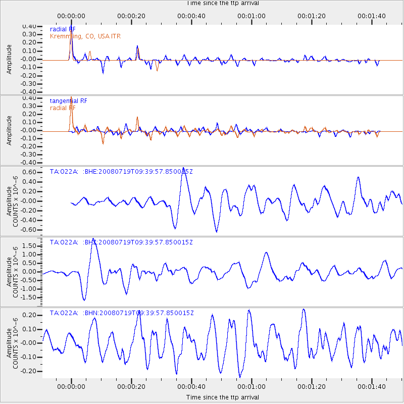
Signal To Noise
| Channel | StoN | STA | LTA |
| TA:O22A: :BHZ:20080719T09:39:57.850015Z | 8.683998 | 7.40729E-7 | 8.5298154E-8 |
| TA:O22A: :BHN:20080719T09:39:57.850015Z | 1.3454299 | 6.097551E-8 | 4.5320466E-8 |
| TA:O22A: :BHE:20080719T09:39:57.850015Z | 4.514676 | 2.3673655E-7 | 5.2437105E-8 |
| Arrivals |
| Ps | 4.5 SECOND |
| PpPs | 12 SECOND |
| PsPs/PpSs | 17 SECOND |


