You are here: Home > Network List > TA - USArray Transportable Network (new EarthScope stations) Stations List
> Station O22A Kremmling, CO, USA > Earthquake Result Viewer
O22A Kremmling, CO, USA - Earthquake Result Viewer
| Earthquake location: |
Norwegian Sea |
| Earthquake latitude/longitude: |
72.2/0.9 |
| Earthquake time(UTC): |
2009/08/20 (232) 06:35:04 GMT |
| Earthquake Depth: |
6.0 km |
| Earthquake Magnitude: |
5.9 MB, 5.7 MS, 6.0 MW, 6.0 MW |
| Earthquake Catalog/Contributor: |
WHDF/NEIC |
|
| Network: |
TA USArray Transportable Network (new EarthScope stations) |
| Station: |
O22A Kremmling, CO, USA |
| Lat/Lon: |
40.16 N/106.55 W |
| Elevation: |
2747 m |
|
| Distance: |
57.3 deg |
| Az: |
299.691 deg |
| Baz: |
20.404 deg |
| Ray Param: |
0.063596204 |
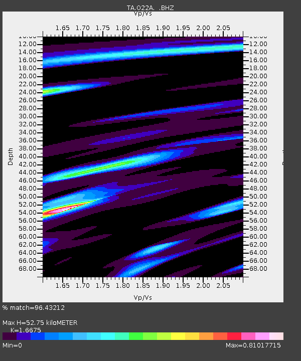
| Estimated Moho Depth: |
52.75 km |
| Estimated Crust Vp/Vs: |
1.67 |
| Assumed Crust Vp: |
6.159 km/s |
| Estimated Crust Vs: |
3.693 km/s |
| Estimated Crust Poisson's Ratio: |
0.22 |
|
| Radial Match: |
96.43212 % |
| Radial Bump: |
304 |
| Transverse Match: |
83.74544 % |
| Transverse Bump: |
400 |
| SOD ConfigId: |
2622 |
| Insert Time: |
2010-03-06 11:15:10.608 +0000 |
| GWidth: |
2.5 |
| Max Bumps: |
400 |
| Tol: |
0.001 |
|
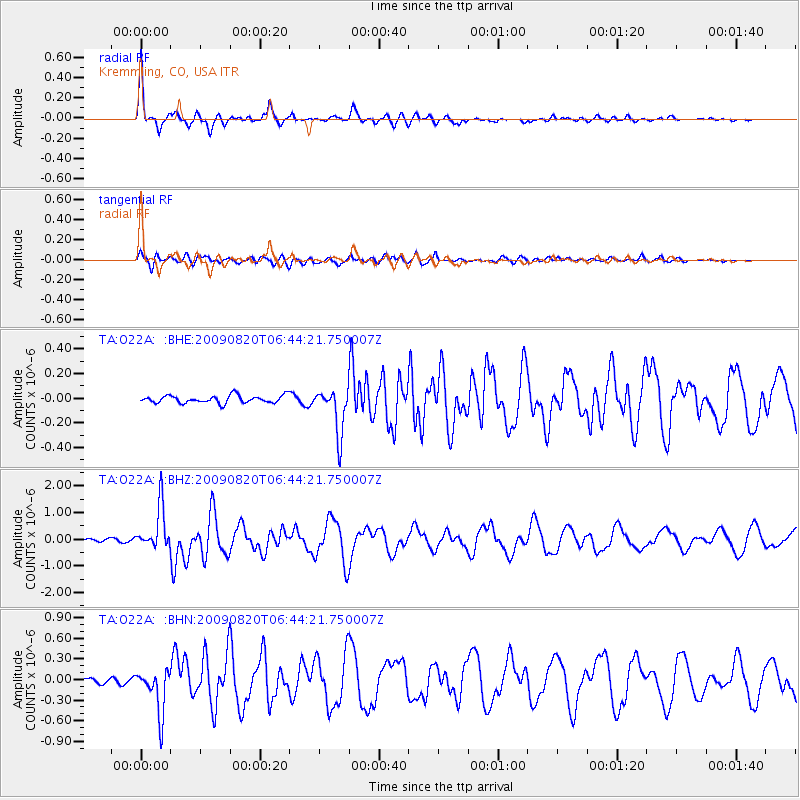
Signal To Noise
| Channel | StoN | STA | LTA |
| TA:O22A: :BHZ:20090820T06:44:21.750007Z | 16.629023 | 8.0920506E-7 | 4.8662212E-8 |
| TA:O22A: :BHN:20090820T06:44:21.750007Z | 9.9072895 | 3.254843E-7 | 3.2853013E-8 |
| TA:O22A: :BHE:20090820T06:44:21.750007Z | 6.0976276 | 1.8747751E-7 | 3.0745973E-8 |
| Arrivals |
| Ps | 6.0 SECOND |
| PpPs | 22 SECOND |
| PsPs/PpSs | 28 SECOND |


