You are here: Home > Network List > TA - USArray Transportable Network (new EarthScope stations) Stations List
> Station O22A Kremmling, CO, USA > Earthquake Result Viewer
O22A Kremmling, CO, USA - Earthquake Result Viewer
| Earthquake location: |
Ryukyu Islands, Japan |
| Earthquake latitude/longitude: |
29.2/129.8 |
| Earthquake time(UTC): |
2009/10/30 (303) 07:03:39 GMT |
| Earthquake Depth: |
34 km |
| Earthquake Magnitude: |
6.3 MB, 6.8 MS, 6.8 MW, 6.8 MW |
| Earthquake Catalog/Contributor: |
WHDF/NEIC |
|
| Network: |
TA USArray Transportable Network (new EarthScope stations) |
| Station: |
O22A Kremmling, CO, USA |
| Lat/Lon: |
40.16 N/106.55 W |
| Elevation: |
2747 m |
|
| Distance: |
93.4 deg |
| Az: |
39.711 deg |
| Baz: |
313.215 deg |
| Ray Param: |
0.041255374 |
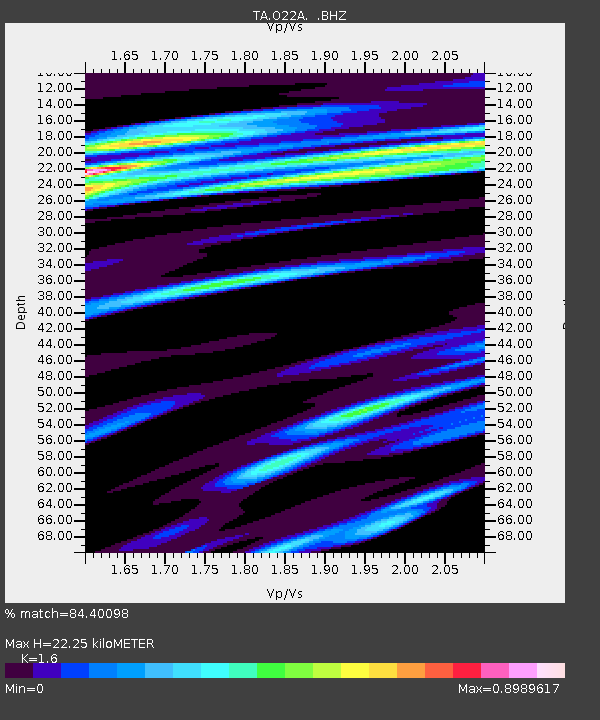
| Estimated Moho Depth: |
22.25 km |
| Estimated Crust Vp/Vs: |
1.60 |
| Assumed Crust Vp: |
6.159 km/s |
| Estimated Crust Vs: |
3.849 km/s |
| Estimated Crust Poisson's Ratio: |
0.18 |
|
| Radial Match: |
84.40098 % |
| Radial Bump: |
400 |
| Transverse Match: |
56.462616 % |
| Transverse Bump: |
400 |
| SOD ConfigId: |
2622 |
| Insert Time: |
2010-03-06 11:15:23.015 +0000 |
| GWidth: |
2.5 |
| Max Bumps: |
400 |
| Tol: |
0.001 |
|
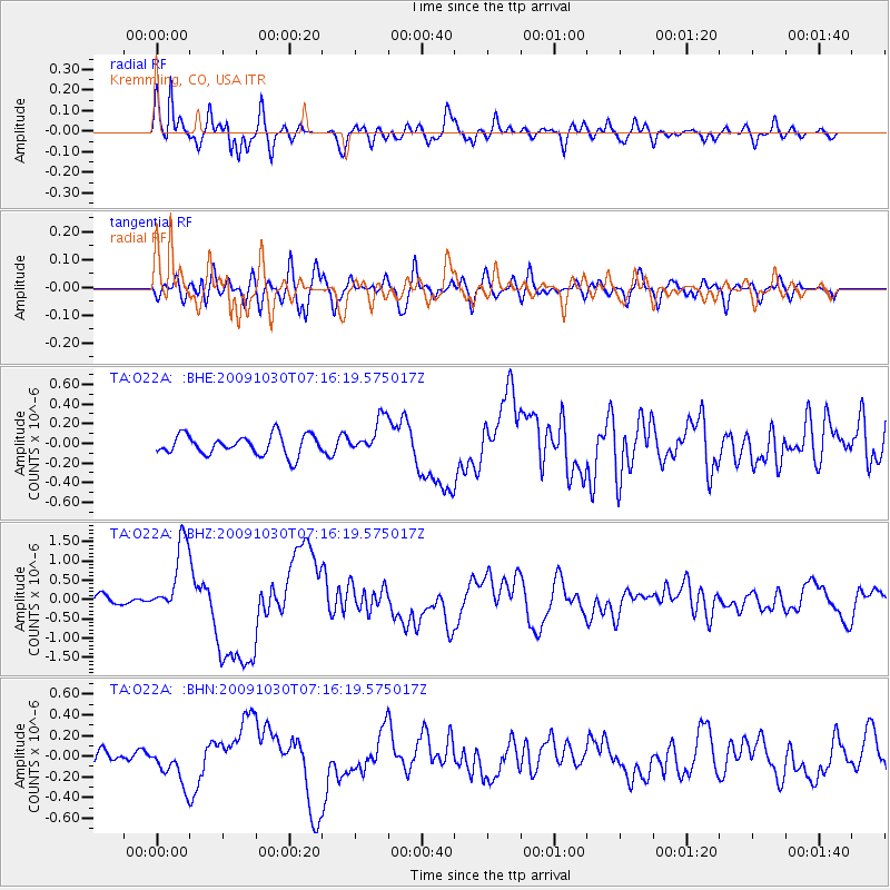
Signal To Noise
| Channel | StoN | STA | LTA |
| TA:O22A: :BHZ:20091030T07:16:19.575017Z | 6.5683045 | 9.529962E-7 | 1.4509013E-7 |
| TA:O22A: :BHN:20091030T07:16:19.575017Z | 1.8698074 | 1.884338E-7 | 1.0077712E-7 |
| TA:O22A: :BHE:20091030T07:16:19.575017Z | 1.7975265 | 1.8086105E-7 | 1.00616624E-7 |
| Arrivals |
| Ps | 2.2 SECOND |
| PpPs | 9.2 SECOND |
| PsPs/PpSs | 11 SECOND |


