You are here: Home > Network List > TA - USArray Transportable Network (new EarthScope stations) Stations List
> Station B18K Kokolik River, AK, USA > Earthquake Result Viewer
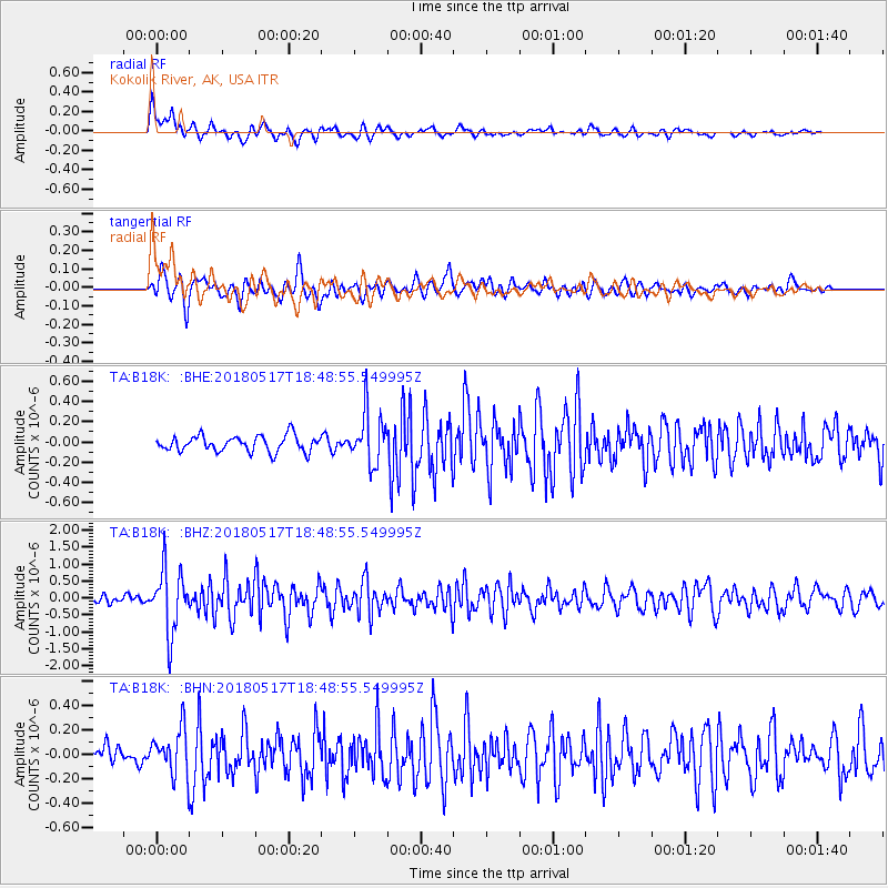
B18K Kokolik River, AK, USA - Earthquake Result Viewer
*The percent match for this event was below the threshold and hence no stack was calculated.
| Earthquake location: |
Hokkaido, Japan Region |
| Earthquake latitude/longitude: |
42.7/145.6 |
| Earthquake time(UTC): |
2018/05/17 (137) 18:42:10 GMT |
| Earthquake Depth: |
10 km |
| Earthquake Magnitude: |
5.8 Mww |
| Earthquake Catalog/Contributor: |
NEIC PDE/us |
|
| Network: |
TA USArray Transportable Network (new EarthScope stations) |
| Station: |
B18K Kokolik River, AK, USA |
| Lat/Lon: |
69.36 N/161.80 W |
| Elevation: |
222 m |
|
| Distance: |
37.8 deg |
| Az: |
27.363 deg |
| Baz: |
252.97 deg |
| Ray Param: |
$rayparam |
*The percent match for this event was below the threshold and hence was not used in the summary stack. |
|
| Radial Match: |
79.94499 % |
| Radial Bump: |
400 |
| Transverse Match: |
70.925644 % |
| Transverse Bump: |
400 |
| SOD ConfigId: |
13570011 |
| Insert Time: |
2019-04-30 06:37:54.665 +0000 |
| GWidth: |
2.5 |
| Max Bumps: |
400 |
| Tol: |
0.001 |
|
Signal To Noise
| Channel | StoN | STA | LTA |
| TA:B18K: :BHZ:20180517T18:48:55.549995Z | 11.067555 | 9.3751515E-7 | 8.4708425E-8 |
| TA:B18K: :BHN:20180517T18:48:55.549995Z | 2.233244 | 1.7769592E-7 | 7.956852E-8 |
| TA:B18K: :BHE:20180517T18:48:55.549995Z | 3.216372 | 2.553596E-7 | 7.939367E-8 |
| Arrivals |
| Ps | |
| PpPs | |
| PsPs/PpSs | |


