You are here: Home > Network List > TA - USArray Transportable Network (new EarthScope stations) Stations List
> Station C18K Utukok River, AK, USA > Earthquake Result Viewer
C18K Utukok River, AK, USA - Earthquake Result Viewer
| Earthquake location: |
Hokkaido, Japan Region |
| Earthquake latitude/longitude: |
42.7/145.6 |
| Earthquake time(UTC): |
2018/05/17 (137) 18:42:10 GMT |
| Earthquake Depth: |
10 km |
| Earthquake Magnitude: |
5.8 Mww |
| Earthquake Catalog/Contributor: |
NEIC PDE/us |
|
| Network: |
TA USArray Transportable Network (new EarthScope stations) |
| Station: |
C18K Utukok River, AK, USA |
| Lat/Lon: |
68.65 N/161.19 W |
| Elevation: |
845 m |
|
| Distance: |
37.8 deg |
| Az: |
28.59 deg |
| Baz: |
254.506 deg |
| Ray Param: |
0.07593559 |
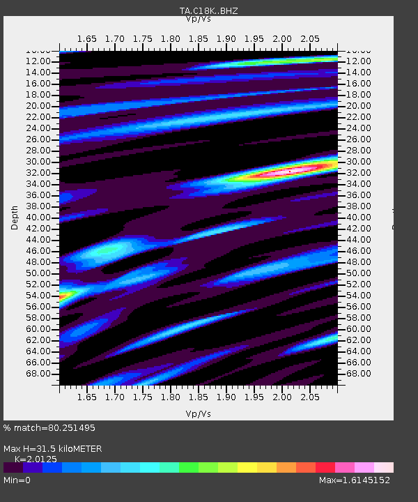
| Estimated Moho Depth: |
31.5 km |
| Estimated Crust Vp/Vs: |
2.01 |
| Assumed Crust Vp: |
5.906 km/s |
| Estimated Crust Vs: |
2.935 km/s |
| Estimated Crust Poisson's Ratio: |
0.34 |
|
| Radial Match: |
80.251495 % |
| Radial Bump: |
400 |
| Transverse Match: |
76.94385 % |
| Transverse Bump: |
400 |
| SOD ConfigId: |
13570011 |
| Insert Time: |
2019-04-30 06:37:59.462 +0000 |
| GWidth: |
2.5 |
| Max Bumps: |
400 |
| Tol: |
0.001 |
|

Signal To Noise
| Channel | StoN | STA | LTA |
| TA:C18K: :BHZ:20180517T18:48:55.625007Z | 8.9688225 | 4.5854972E-7 | 5.1127085E-8 |
| TA:C18K: :BHN:20180517T18:48:55.625007Z | 3.6173031 | 1.4991824E-7 | 4.1444753E-8 |
| TA:C18K: :BHE:20180517T18:48:55.625007Z | 4.806575 | 2.6012674E-7 | 5.411894E-8 |
| Arrivals |
| Ps | 5.7 SECOND |
| PpPs | 15 SECOND |
| PsPs/PpSs | 21 SECOND |


