You are here: Home > Network List > TA - USArray Transportable Network (new EarthScope stations) Stations List
> Station F14K Arctic Creek, AK, USA > Earthquake Result Viewer
F14K Arctic Creek, AK, USA - Earthquake Result Viewer
| Earthquake location: |
Hokkaido, Japan Region |
| Earthquake latitude/longitude: |
42.7/145.6 |
| Earthquake time(UTC): |
2018/05/17 (137) 18:42:10 GMT |
| Earthquake Depth: |
10 km |
| Earthquake Magnitude: |
5.8 Mww |
| Earthquake Catalog/Contributor: |
NEIC PDE/us |
|
| Network: |
TA USArray Transportable Network (new EarthScope stations) |
| Station: |
F14K Arctic Creek, AK, USA |
| Lat/Lon: |
65.47 N/166.33 W |
| Elevation: |
266 m |
|
| Distance: |
35.0 deg |
| Az: |
32.805 deg |
| Baz: |
253.175 deg |
| Ray Param: |
0.077465825 |
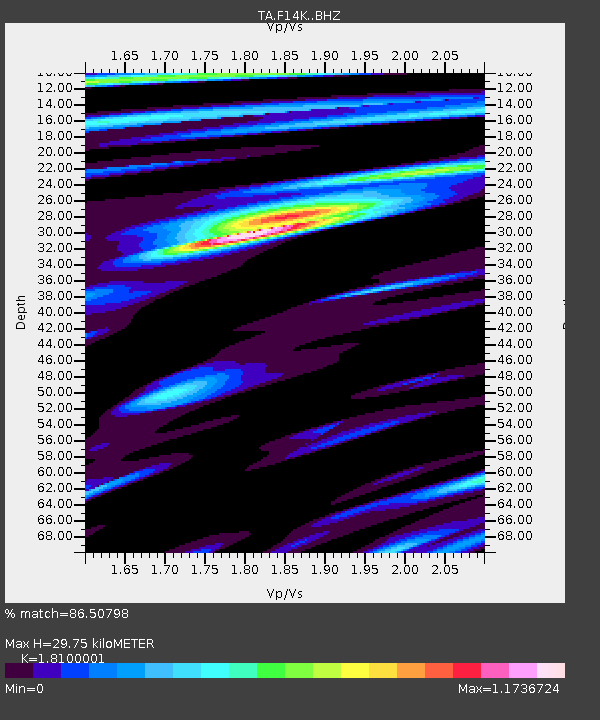
| Estimated Moho Depth: |
29.75 km |
| Estimated Crust Vp/Vs: |
1.81 |
| Assumed Crust Vp: |
6.307 km/s |
| Estimated Crust Vs: |
3.484 km/s |
| Estimated Crust Poisson's Ratio: |
0.28 |
|
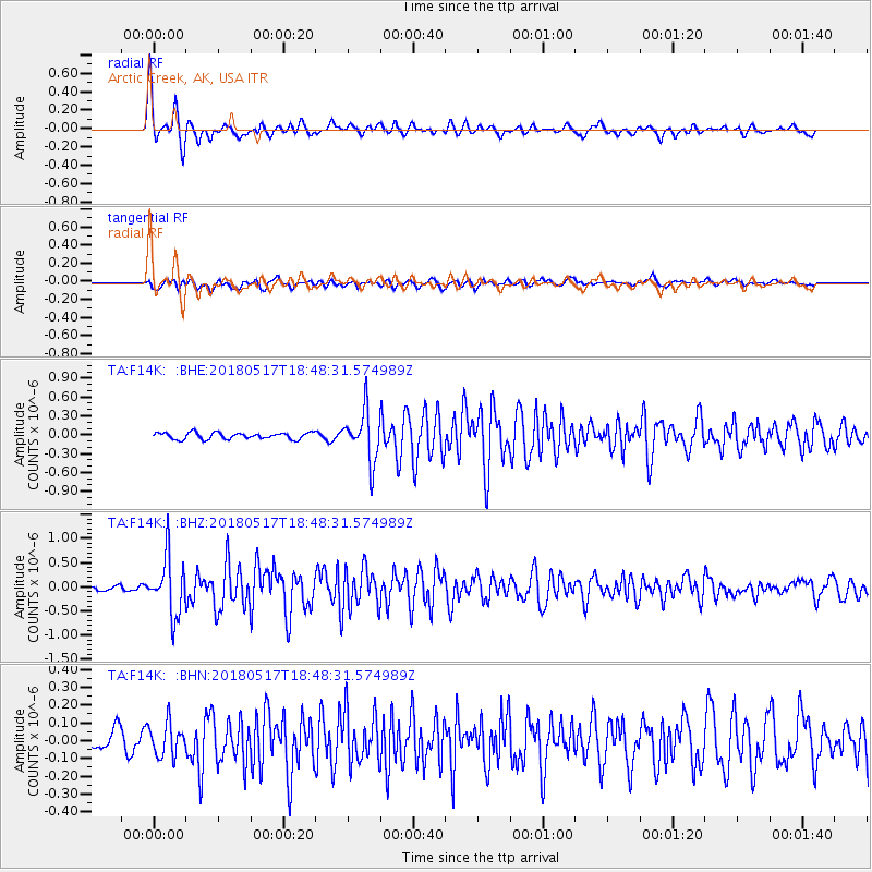
| Radial Match: |
86.50798 % |
| Radial Bump: |
305 |
| Transverse Match: |
69.212906 % |
| Transverse Bump: |
400 |
| SOD ConfigId: |
13570011 |
| Insert Time: |
2019-04-30 06:38:21.450 +0000 |
| GWidth: |
2.5 |
| Max Bumps: |
400 |
| Tol: |
0.001 |
|
Signal To Noise
| Channel | StoN | STA | LTA |
| TA:F14K: :BHZ:20180517T18:48:31.574989Z | 8.325799 | 5.967206E-7 | 7.167127E-8 |
| TA:F14K: :BHN:20180517T18:48:31.574989Z | 1.1019284 | 9.237434E-8 | 8.382972E-8 |
| TA:F14K: :BHE:20180517T18:48:31.574989Z | 7.8205876 | 4.2156188E-7 | 5.3904117E-8 |
| Arrivals |
| Ps | 4.1 SECOND |
| PpPs | 12 SECOND |
| PsPs/PpSs | 16 SECOND |


