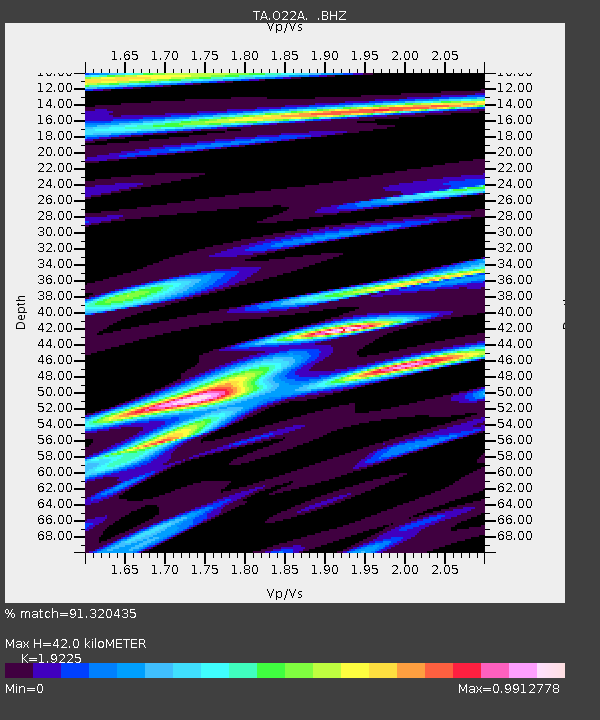
O22A Kremmling, CO, USA - Earthquake Result Viewer
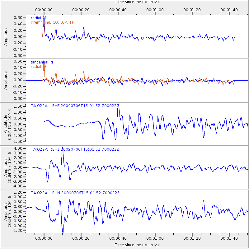
Earthquake location: Rat Islands, Aleutian Islands
Earthquake latitude/longitude: 50.4/177.0
Earthquake time(UTC): 2009/07/06 (187) 14:53:12 GMT
Earthquake Depth: 22 km
Earthquake Magnitude: 6.0 MB, 5.8 MS, 6.1 MW, 6.0 MW
Earthquake Catalog/Contributor: WHDF/NEIC
Network: TA USArray Transportable Network (new EarthScope stations)
Station: O22A Kremmling, CO, USA
Lat/Lon: 40.16 N/106.55 W
Elevation: 2747 m
Distance: 52.5 deg
Az: 69.884 deg
Baz: 308.413 deg
Ray Param: 0.06668336
Estimated Moho Depth: 42.0 km
Estimated Crust Vp/Vs: 1.92
Assumed Crust Vp: 6.159 km/s
Estimated Crust Vs: 3.203 km/s
Estimated Crust Poisson's Ratio: 0.31
Radial Match: 91.320435 %
Radial Bump: 400
Transverse Match: 57.64357 %
Transverse Bump: 400
SOD ConfigId: 2648
Insert Time: 2010-03-06 11:15:41.751 +0000
GWidth: 2.5
Max Bumps: 400
Tol: 0.001

Signal To Noise

ChannelStoNSTALTA
TA:O22A: :BHZ:20090706T15:01:52.700022Z11.1620621.318202E-61.18096644E-7
TA:O22A: :BHN:20090706T15:01:52.700022Z1.48666513.8957268E-72.6204467E-7
TA:O22A: :BHE:20090706T15:01:52.700022Z3.39696965.699733E-71.6778876E-7
Arrivals
Ps6.6 SECOND
PpPs19 SECOND
PsPs/PpSs26 SECOND