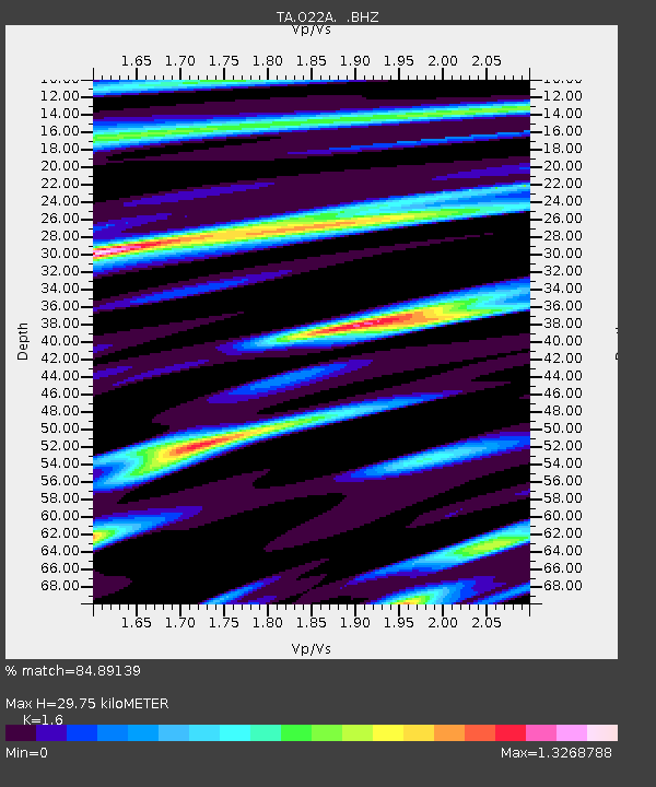
O22A Kremmling, CO, USA - Earthquake Result Viewer
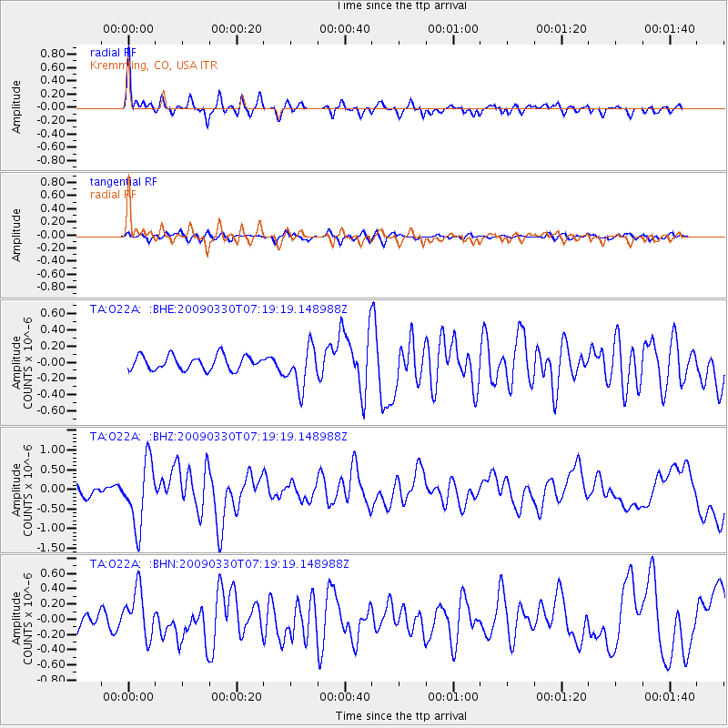
Earthquake location: Kodiak Island Region, Alaska
Earthquake latitude/longitude: 56.5/-152.7
Earthquake time(UTC): 2009/03/30 (089) 07:13:07 GMT
Earthquake Depth: 21 km
Earthquake Magnitude: 5.9 MB, 5.9 MS, 5.9 MW, 5.9 MW
Earthquake Catalog/Contributor: WHDF/NEIC
Network: TA USArray Transportable Network (new EarthScope stations)
Station: O22A Kremmling, CO, USA
Lat/Lon: 40.16 N/106.55 W
Elevation: 2747 m
Distance: 34.0 deg
Az: 98.826 deg
Baz: 314.427 deg
Ray Param: 0.0779086
Estimated Moho Depth: 29.75 km
Estimated Crust Vp/Vs: 1.60
Assumed Crust Vp: 6.159 km/s
Estimated Crust Vs: 3.849 km/s
Estimated Crust Poisson's Ratio: 0.18
Radial Match: 84.89139 %
Radial Bump: 400
Transverse Match: 62.06683 %
Transverse Bump: 400
SOD ConfigId: 2658
Insert Time: 2010-03-06 11:15:44.705 +0000
GWidth: 2.5
Max Bumps: 400
Tol: 0.001

Signal To Noise

ChannelStoNSTALTA
TA:O22A: :BHZ:20090330T07:19:19.148988Z7.138448.284176E-71.1605023E-7
TA:O22A: :BHN:20090330T07:19:19.148988Z3.62161973.1231906E-78.623739E-8
TA:O22A: :BHE:20090330T07:19:19.148988Z2.9524552.5841686E-78.75261E-8
Arrivals
Ps3.1 SECOND
PpPs12 SECOND
PsPs/PpSs15 SECOND