You are here: Home > Network List > TA - USArray Transportable Network (new EarthScope stations) Stations List
> Station F30M Barrier River, YT, CAN > Earthquake Result Viewer
F30M Barrier River, YT, CAN - Earthquake Result Viewer
| Earthquake location: |
Hokkaido, Japan Region |
| Earthquake latitude/longitude: |
42.7/145.6 |
| Earthquake time(UTC): |
2018/05/17 (137) 18:42:10 GMT |
| Earthquake Depth: |
10 km |
| Earthquake Magnitude: |
5.8 Mww |
| Earthquake Catalog/Contributor: |
NEIC PDE/us |
|
| Network: |
TA USArray Transportable Network (new EarthScope stations) |
| Station: |
F30M Barrier River, YT, CAN |
| Lat/Lon: |
67.61 N/135.79 W |
| Elevation: |
414 m |
|
| Distance: |
47.2 deg |
| Az: |
30.795 deg |
| Baz: |
279.749 deg |
| Ray Param: |
0.07015912 |
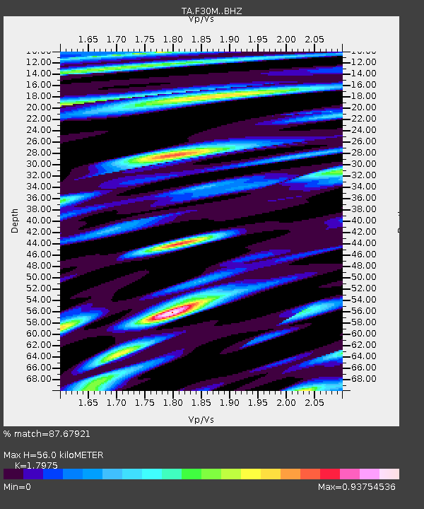
| Estimated Moho Depth: |
56.0 km |
| Estimated Crust Vp/Vs: |
1.80 |
| Assumed Crust Vp: |
6.171 km/s |
| Estimated Crust Vs: |
3.433 km/s |
| Estimated Crust Poisson's Ratio: |
0.28 |
|
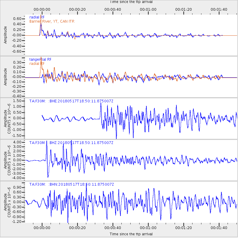
| Radial Match: |
87.67921 % |
| Radial Bump: |
400 |
| Transverse Match: |
85.35006 % |
| Transverse Bump: |
400 |
| SOD ConfigId: |
13570011 |
| Insert Time: |
2019-04-30 06:38:30.963 +0000 |
| GWidth: |
2.5 |
| Max Bumps: |
400 |
| Tol: |
0.001 |
|
Signal To Noise
| Channel | StoN | STA | LTA |
| TA:F30M: :BHZ:20180517T18:50:11.875007Z | 11.673492 | 1.7080242E-6 | 1.4631647E-7 |
| TA:F30M: :BHN:20180517T18:50:11.875007Z | 3.3045077 | 2.7159484E-7 | 8.2189196E-8 |
| TA:F30M: :BHE:20180517T18:50:11.875007Z | 4.0551634 | 4.8396663E-7 | 1.1934578E-7 |
| Arrivals |
| Ps | 7.7 SECOND |
| PpPs | 24 SECOND |
| PsPs/PpSs | 32 SECOND |


