You are here: Home > Network List > TA - USArray Transportable Network (new EarthScope stations) Stations List
> Station G30M túh Zraii Njik, YT, CAN > Earthquake Result Viewer
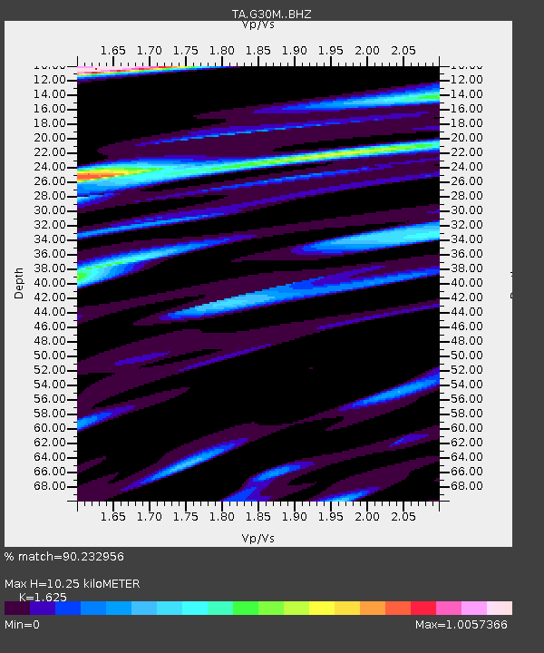
G30M túh Zraii Njik, YT, CAN - Earthquake Result Viewer
| Earthquake location: |
Hokkaido, Japan Region |
| Earthquake latitude/longitude: |
42.7/145.6 |
| Earthquake time(UTC): |
2018/05/17 (137) 18:42:10 GMT |
| Earthquake Depth: |
10 km |
| Earthquake Magnitude: |
5.8 Mww |
| Earthquake Catalog/Contributor: |
NEIC PDE/us |
|
| Network: |
TA USArray Transportable Network (new EarthScope stations) |
| Station: |
G30M túh Zraii Njik, YT, CAN |
| Lat/Lon: |
66.98 N/136.22 W |
| Elevation: |
739 m |
|
| Distance: |
47.1 deg |
| Az: |
31.685 deg |
| Baz: |
279.953 deg |
| Ray Param: |
0.07019791 |
| Estimated Moho Depth: |
10.25 km |
| Estimated Crust Vp/Vs: |
1.62 |
| Assumed Crust Vp: |
6.522 km/s |
| Estimated Crust Vs: |
4.013 km/s |
| Estimated Crust Poisson's Ratio: |
0.20 |
|
| Radial Match: |
90.232956 % |
| Radial Bump: |
400 |
| Transverse Match: |
85.11273 % |
| Transverse Bump: |
400 |
| SOD ConfigId: |
13570011 |
| Insert Time: |
2019-04-30 06:38:42.948 +0000 |
| GWidth: |
2.5 |
| Max Bumps: |
400 |
| Tol: |
0.001 |
|

Signal To Noise
| Channel | StoN | STA | LTA |
| TA:G30M: :BHZ:20180517T18:50:11.400001Z | 12.8884735 | 1.3653198E-6 | 1.05933395E-7 |
| TA:G30M: :BHN:20180517T18:50:11.400001Z | 4.234909 | 3.151244E-7 | 7.441114E-8 |
| TA:G30M: :BHE:20180517T18:50:11.400001Z | 8.902133 | 5.861873E-7 | 6.584796E-8 |
| Arrivals |
| Ps | 1.1 SECOND |
| PpPs | 3.8 SECOND |
| PsPs/PpSs | 4.9 SECOND |


