You are here: Home > Network List > TA - USArray Transportable Network (new EarthScope stations) Stations List
> Station H24K Noodor Dome, AK, USA > Earthquake Result Viewer
H24K Noodor Dome, AK, USA - Earthquake Result Viewer
| Earthquake location: |
Hokkaido, Japan Region |
| Earthquake latitude/longitude: |
42.7/145.6 |
| Earthquake time(UTC): |
2018/05/17 (137) 18:42:10 GMT |
| Earthquake Depth: |
10 km |
| Earthquake Magnitude: |
5.8 Mww |
| Earthquake Catalog/Contributor: |
NEIC PDE/us |
|
| Network: |
TA USArray Transportable Network (new EarthScope stations) |
| Station: |
H24K Noodor Dome, AK, USA |
| Lat/Lon: |
65.84 N/147.88 W |
| Elevation: |
814 m |
|
| Distance: |
42.6 deg |
| Az: |
33.924 deg |
| Baz: |
270.865 deg |
| Ray Param: |
0.07309948 |
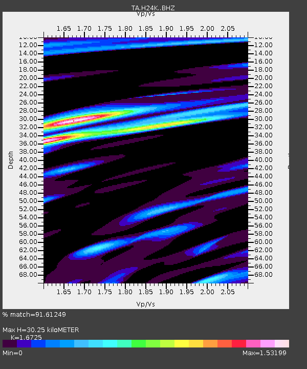
| Estimated Moho Depth: |
30.25 km |
| Estimated Crust Vp/Vs: |
1.67 |
| Assumed Crust Vp: |
6.566 km/s |
| Estimated Crust Vs: |
3.926 km/s |
| Estimated Crust Poisson's Ratio: |
0.22 |
|
| Radial Match: |
91.61249 % |
| Radial Bump: |
400 |
| Transverse Match: |
78.43444 % |
| Transverse Bump: |
400 |
| SOD ConfigId: |
13570011 |
| Insert Time: |
2019-04-30 06:38:51.309 +0000 |
| GWidth: |
2.5 |
| Max Bumps: |
400 |
| Tol: |
0.001 |
|

Signal To Noise
| Channel | StoN | STA | LTA |
| TA:H24K: :BHZ:20180517T18:49:35.150001Z | 12.694364 | 9.2209825E-7 | 7.26384E-8 |
| TA:H24K: :BHN:20180517T18:49:35.150001Z | 1.7301273 | 8.505971E-8 | 4.9163845E-8 |
| TA:H24K: :BHE:20180517T18:49:35.150001Z | 8.5307455 | 4.6258026E-7 | 5.422507E-8 |
| Arrivals |
| Ps | 3.3 SECOND |
| PpPs | 11 SECOND |
| PsPs/PpSs | 15 SECOND |


