You are here: Home > Network List > TA - USArray Transportable Network (new EarthScope stations) Stations List
> Station L18K Granite Mountain, AK, USA > Earthquake Result Viewer
L18K Granite Mountain, AK, USA - Earthquake Result Viewer
| Earthquake location: |
Hokkaido, Japan Region |
| Earthquake latitude/longitude: |
42.7/145.6 |
| Earthquake time(UTC): |
2018/05/17 (137) 18:42:10 GMT |
| Earthquake Depth: |
10 km |
| Earthquake Magnitude: |
5.8 Mww |
| Earthquake Catalog/Contributor: |
NEIC PDE/us |
|
| Network: |
TA USArray Transportable Network (new EarthScope stations) |
| Station: |
L18K Granite Mountain, AK, USA |
| Lat/Lon: |
62.22 N/156.69 W |
| Elevation: |
329 m |
|
| Distance: |
38.6 deg |
| Az: |
39.385 deg |
| Baz: |
267.098 deg |
| Ray Param: |
0.0754542 |
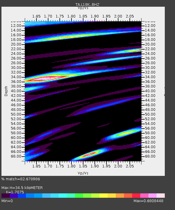
| Estimated Moho Depth: |
34.5 km |
| Estimated Crust Vp/Vs: |
1.71 |
| Assumed Crust Vp: |
6.182 km/s |
| Estimated Crust Vs: |
3.621 km/s |
| Estimated Crust Poisson's Ratio: |
0.24 |
|
| Radial Match: |
82.678986 % |
| Radial Bump: |
400 |
| Transverse Match: |
75.508255 % |
| Transverse Bump: |
400 |
| SOD ConfigId: |
13570011 |
| Insert Time: |
2019-04-30 06:39:23.590 +0000 |
| GWidth: |
2.5 |
| Max Bumps: |
400 |
| Tol: |
0.001 |
|

Signal To Noise
| Channel | StoN | STA | LTA |
| TA:L18K: :BHZ:20180517T18:49:02.574989Z | 3.656408 | 5.146118E-7 | 1.4074244E-7 |
| TA:L18K: :BHN:20180517T18:49:02.574989Z | 1.3269647 | 1.3282717E-7 | 1.0009849E-7 |
| TA:L18K: :BHE:20180517T18:49:02.574989Z | 2.5684252 | 2.2916485E-7 | 8.9223875E-8 |
| Arrivals |
| Ps | 4.2 SECOND |
| PpPs | 14 SECOND |
| PsPs/PpSs | 18 SECOND |


