You are here: Home > Network List > TA - USArray Transportable Network (new EarthScope stations) Stations List
> Station M26K Nabesna, AK, USA > Earthquake Result Viewer
M26K Nabesna, AK, USA - Earthquake Result Viewer
| Earthquake location: |
Hokkaido, Japan Region |
| Earthquake latitude/longitude: |
42.7/145.6 |
| Earthquake time(UTC): |
2018/05/17 (137) 18:42:10 GMT |
| Earthquake Depth: |
10 km |
| Earthquake Magnitude: |
5.8 Mww |
| Earthquake Catalog/Contributor: |
NEIC PDE/us |
|
| Network: |
TA USArray Transportable Network (new EarthScope stations) |
| Station: |
M26K Nabesna, AK, USA |
| Lat/Lon: |
62.40 N/143.00 W |
| Elevation: |
888 m |
|
| Distance: |
45.0 deg |
| Az: |
38.633 deg |
| Baz: |
278.656 deg |
| Ray Param: |
0.07157281 |
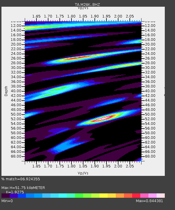
| Estimated Moho Depth: |
51.75 km |
| Estimated Crust Vp/Vs: |
1.93 |
| Assumed Crust Vp: |
6.566 km/s |
| Estimated Crust Vs: |
3.407 km/s |
| Estimated Crust Poisson's Ratio: |
0.32 |
|
| Radial Match: |
86.924355 % |
| Radial Bump: |
399 |
| Transverse Match: |
77.80228 % |
| Transverse Bump: |
400 |
| SOD ConfigId: |
13570011 |
| Insert Time: |
2019-04-30 06:39:36.185 +0000 |
| GWidth: |
2.5 |
| Max Bumps: |
400 |
| Tol: |
0.001 |
|

Signal To Noise
| Channel | StoN | STA | LTA |
| TA:M26K: :BHZ:20180517T18:49:54.574989Z | 8.349936 | 5.0167125E-7 | 6.008085E-8 |
| TA:M26K: :BHN:20180517T18:49:54.574989Z | 1.5883576 | 9.4676295E-8 | 5.9606414E-8 |
| TA:M26K: :BHE:20180517T18:49:54.574989Z | 3.2767384 | 2.2728798E-7 | 6.936409E-8 |
| Arrivals |
| Ps | 7.8 SECOND |
| PpPs | 22 SECOND |
| PsPs/PpSs | 29 SECOND |


