You are here: Home > Network List > TA - USArray Transportable Network (new EarthScope stations) Stations List
> Station MSTX Muleshoe, TX, USA > Earthquake Result Viewer
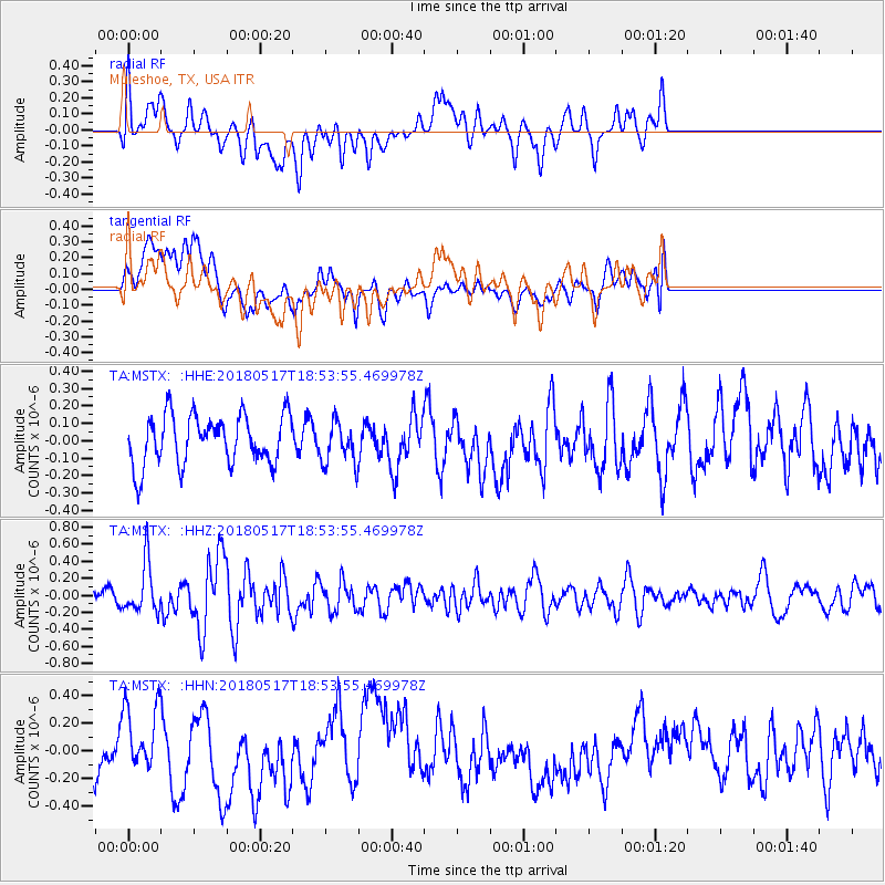
MSTX Muleshoe, TX, USA - Earthquake Result Viewer
*The percent match for this event was below the threshold and hence no stack was calculated.
| Earthquake location: |
Hokkaido, Japan Region |
| Earthquake latitude/longitude: |
42.7/145.6 |
| Earthquake time(UTC): |
2018/05/17 (137) 18:42:10 GMT |
| Earthquake Depth: |
10 km |
| Earthquake Magnitude: |
5.8 Mww |
| Earthquake Catalog/Contributor: |
NEIC PDE/us |
|
| Network: |
TA USArray Transportable Network (new EarthScope stations) |
| Station: |
MSTX Muleshoe, TX, USA |
| Lat/Lon: |
33.97 N/102.77 W |
| Elevation: |
1167 m |
|
| Distance: |
81.4 deg |
| Az: |
51.388 deg |
| Baz: |
316.102 deg |
| Ray Param: |
$rayparam |
*The percent match for this event was below the threshold and hence was not used in the summary stack. |
|
| Radial Match: |
54.82073 % |
| Radial Bump: |
400 |
| Transverse Match: |
44.59608 % |
| Transverse Bump: |
400 |
| SOD ConfigId: |
13570011 |
| Insert Time: |
2019-04-30 06:39:42.149 +0000 |
| GWidth: |
2.5 |
| Max Bumps: |
400 |
| Tol: |
0.001 |
|
Signal To Noise
| Channel | StoN | STA | LTA |
| TA:MSTX: :HHZ:20180517T18:53:55.469978Z | 2.7574363 | 2.9561144E-7 | 1.07205175E-7 |
| TA:MSTX: :HHN:20180517T18:53:55.469978Z | 1.3875108 | 2.443674E-7 | 1.7611927E-7 |
| TA:MSTX: :HHE:20180517T18:53:55.469978Z | 0.83790493 | 1.1884853E-7 | 1.4184012E-7 |
| Arrivals |
| Ps | |
| PpPs | |
| PsPs/PpSs | |


