You are here: Home > Network List > TA - USArray Transportable Network (new EarthScope stations) Stations List
> Station O22A Kremmling, CO, USA > Earthquake Result Viewer
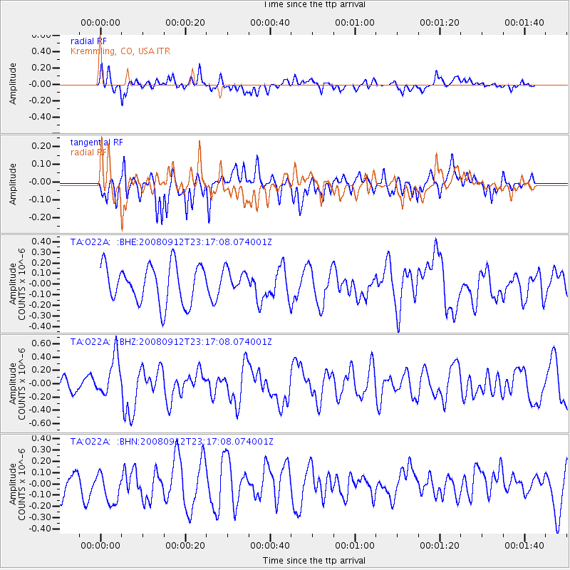
O22A Kremmling, CO, USA - Earthquake Result Viewer
*The percent match for this event was below the threshold and hence no stack was calculated.
| Earthquake location: |
Komandorskiye Ostrova Region |
| Earthquake latitude/longitude: |
56.3/164.1 |
| Earthquake time(UTC): |
2008/09/12 (256) 23:07:50 GMT |
| Earthquake Depth: |
9.3 km |
| Earthquake Magnitude: |
5.5 MB, 5.7 MS, 5.9 MW, 5.9 MW |
| Earthquake Catalog/Contributor: |
WHDF/NEIC |
|
| Network: |
TA USArray Transportable Network (new EarthScope stations) |
| Station: |
O22A Kremmling, CO, USA |
| Lat/Lon: |
40.16 N/106.55 W |
| Elevation: |
2747 m |
|
| Distance: |
57.4 deg |
| Az: |
65.392 deg |
| Baz: |
318.608 deg |
| Ray Param: |
$rayparam |
*The percent match for this event was below the threshold and hence was not used in the summary stack. |
|
| Radial Match: |
63.707596 % |
| Radial Bump: |
400 |
| Transverse Match: |
53.59888 % |
| Transverse Bump: |
400 |
| SOD ConfigId: |
2560 |
| Insert Time: |
2010-03-06 11:16:22.470 +0000 |
| GWidth: |
2.5 |
| Max Bumps: |
400 |
| Tol: |
0.001 |
|
Signal To Noise
| Channel | StoN | STA | LTA |
| TA:O22A: :BHZ:20080912T23:17:08.074001Z | 4.0423274 | 3.1062535E-7 | 7.684319E-8 |
| TA:O22A: :BHN:20080912T23:17:08.074001Z | 1.022136 | 1.4735173E-7 | 1.4416058E-7 |
| TA:O22A: :BHE:20080912T23:17:08.074001Z | 0.5956994 | 1.07154044E-7 | 1.7987938E-7 |
| Arrivals |
| Ps | |
| PpPs | |
| PsPs/PpSs | |


