You are here: Home > Network List > NE - New England Seismic Network Stations List
> Station PQI Presque Isle, ME, USA > Earthquake Result Viewer
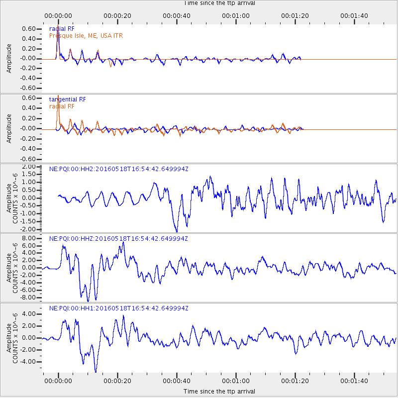
PQI Presque Isle, ME, USA - Earthquake Result Viewer

| Earthquake location: |
Near Coast Of Ecuador |
| Earthquake latitude/longitude: |
0.5/-79.6 |
| Earthquake time(UTC): |
2016/05/18 (139) 16:46:44 GMT |
| Earthquake Depth: |
31 km |
| Earthquake Magnitude: |
6.8 MO |
| Earthquake Catalog/Contributor: |
NEIC PDE/NEIC ALERT |
|
| Network: |
NE New England Seismic Network |
| Station: |
PQI Presque Isle, ME, USA |
| Lat/Lon: |
46.67 N/68.02 W |
| Elevation: |
162 m |
|
| Distance: |
47.1 deg |
| Az: |
10.91 deg |
| Baz: |
195.953 deg |
| Ray Param: |
0.07013352 |
| Estimated Moho Depth: |
69.5 km |
| Estimated Crust Vp/Vs: |
1.72 |
| Assumed Crust Vp: |
6.419 km/s |
| Estimated Crust Vs: |
3.743 km/s |
| Estimated Crust Poisson's Ratio: |
0.24 |
|
| Radial Match: |
92.38905 % |
| Radial Bump: |
280 |
| Transverse Match: |
84.24275 % |
| Transverse Bump: |
400 |
| SOD ConfigId: |
1475611 |
| Insert Time: |
2016-06-01 16:54:36.784 +0000 |
| GWidth: |
2.5 |
| Max Bumps: |
400 |
| Tol: |
0.001 |
|
Signal To Noise
| Channel | StoN | STA | LTA |
| NE:PQI:00:HHZ:20160518T16:54:42.649994Z | 8.821131 | 3.2356916E-6 | 3.6681143E-7 |
| NE:PQI:00:HH1:20160518T16:54:42.649994Z | 7.0451736 | 1.6715603E-6 | 2.3726318E-7 |
| NE:PQI:00:HH2:20160518T16:54:42.649994Z | 2.0575142 | 5.365296E-7 | 2.6076592E-7 |
| Arrivals |
| Ps | 8.2 SECOND |
| PpPs | 28 SECOND |
| PsPs/PpSs | 36 SECOND |


