You are here: Home > Network List > TA - USArray Transportable Network (new EarthScope stations) Stations List
> Station O22A Kremmling, CO, USA > Earthquake Result Viewer
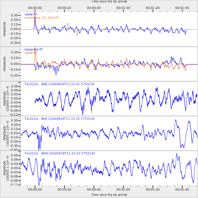
O22A Kremmling, CO, USA - Earthquake Result Viewer
*The percent match for this event was below the threshold and hence no stack was calculated.
| Earthquake location: |
South Of Fiji Islands |
| Earthquake latitude/longitude: |
-26.1/-178.4 |
| Earthquake time(UTC): |
2009/08/18 (230) 21:20:47 GMT |
| Earthquake Depth: |
270 km |
| Earthquake Magnitude: |
5.5 MB, 6.3 MW, 6.3 MW |
| Earthquake Catalog/Contributor: |
WHDF/NEIC |
|
| Network: |
TA USArray Transportable Network (new EarthScope stations) |
| Station: |
O22A Kremmling, CO, USA |
| Lat/Lon: |
40.16 N/106.55 W |
| Elevation: |
2747 m |
|
| Distance: |
93.8 deg |
| Az: |
46.869 deg |
| Baz: |
238.931 deg |
| Ray Param: |
$rayparam |
*The percent match for this event was below the threshold and hence was not used in the summary stack. |
|
| Radial Match: |
61.129974 % |
| Radial Bump: |
400 |
| Transverse Match: |
63.704464 % |
| Transverse Bump: |
400 |
| SOD ConfigId: |
2622 |
| Insert Time: |
2010-03-06 11:16:39.966 +0000 |
| GWidth: |
2.5 |
| Max Bumps: |
400 |
| Tol: |
0.001 |
|
Signal To Noise
| Channel | StoN | STA | LTA |
| TA:O22A: :BHZ:20090818T21:33:02.575024Z | 4.00147 | 1.5562921E-7 | 3.8893006E-8 |
| TA:O22A: :BHN:20090818T21:33:02.575024Z | 2.530497 | 6.167686E-8 | 2.4373415E-8 |
| TA:O22A: :BHE:20090818T21:33:02.575024Z | 1.5566692 | 5.1380685E-8 | 3.300681E-8 |
| Arrivals |
| Ps | |
| PpPs | |
| PsPs/PpSs | |


