You are here: Home > Network List > CI - Caltech Regional Seismic Network Stations List
> Station TOV Thousand Oaks, California, USA > Earthquake Result Viewer
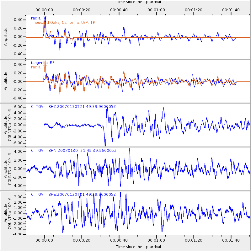
TOV Thousand Oaks, California, USA - Earthquake Result Viewer

| Earthquake location: |
Mariana Islands |
| Earthquake latitude/longitude: |
21.0/144.7 |
| Earthquake time(UTC): |
2007/01/30 (030) 21:37:45 GMT |
| Earthquake Depth: |
30 km |
| Earthquake Magnitude: |
6.3 MB, 6.5 MS, 6.6 MW, 6.5 MW |
| Earthquake Catalog/Contributor: |
WHDF/NEIC |
|
| Network: |
CI Caltech Regional Seismic Network |
| Station: |
TOV Thousand Oaks, California, USA |
| Lat/Lon: |
34.16 N/118.82 W |
| Elevation: |
50 m |
|
| Distance: |
83.6 deg |
| Az: |
56.008 deg |
| Baz: |
290.882 deg |
| Ray Param: |
0.046034075 |
| Estimated Moho Depth: |
41.75 km |
| Estimated Crust Vp/Vs: |
2.04 |
| Assumed Crust Vp: |
6.1 km/s |
| Estimated Crust Vs: |
2.987 km/s |
| Estimated Crust Poisson's Ratio: |
0.34 |
|
| Radial Match: |
81.81944 % |
| Radial Bump: |
400 |
| Transverse Match: |
82.63352 % |
| Transverse Bump: |
400 |
| SOD ConfigId: |
2564 |
| Insert Time: |
2010-02-26 01:58:17.785 +0000 |
| GWidth: |
2.5 |
| Max Bumps: |
400 |
| Tol: |
0.001 |
|
Signal To Noise
| Channel | StoN | STA | LTA |
| CI:TOV: :BHN:20070130T21:49:39.960005Z | 1.1164511 | 4.824208E-7 | 4.32102E-7 |
| CI:TOV: :BHE:20070130T21:49:39.960005Z | 1.5353992 | 9.413739E-7 | 6.1311346E-7 |
| CI:TOV: :BHZ:20070130T21:49:39.960005Z | 8.686409 | 3.0711838E-6 | 3.5356194E-7 |
| Arrivals |
| Ps | 7.3 SECOND |
| PpPs | 20 SECOND |
| PsPs/PpSs | 28 SECOND |


