You are here: Home > Network List > NM - Cooperative New Madrid Seismic Network Stations List
> Station LPAR Lepanto,AR > Earthquake Result Viewer
LPAR Lepanto,AR - Earthquake Result Viewer
| Earthquake location: |
Near Coast Of Ecuador |
| Earthquake latitude/longitude: |
0.5/-79.6 |
| Earthquake time(UTC): |
2016/05/18 (139) 16:46:44 GMT |
| Earthquake Depth: |
31 km |
| Earthquake Magnitude: |
6.8 MO |
| Earthquake Catalog/Contributor: |
NEIC PDE/NEIC ALERT |
|
| Network: |
NM Cooperative New Madrid Seismic Network |
| Station: |
LPAR Lepanto,AR |
| Lat/Lon: |
35.60 N/90.30 W |
| Elevation: |
67 m |
|
| Distance: |
36.3 deg |
| Az: |
345.264 deg |
| Baz: |
161.812 deg |
| Ray Param: |
0.07667804 |
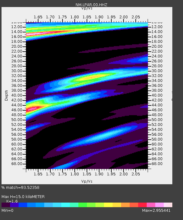
| Estimated Moho Depth: |
15.0 km |
| Estimated Crust Vp/Vs: |
1.60 |
| Assumed Crust Vp: |
6.273 km/s |
| Estimated Crust Vs: |
3.921 km/s |
| Estimated Crust Poisson's Ratio: |
0.18 |
|
| Radial Match: |
93.52358 % |
| Radial Bump: |
265 |
| Transverse Match: |
78.83179 % |
| Transverse Bump: |
400 |
| SOD ConfigId: |
1475611 |
| Insert Time: |
2016-06-01 16:55:40.683 +0000 |
| GWidth: |
2.5 |
| Max Bumps: |
400 |
| Tol: |
0.001 |
|

Signal To Noise
| Channel | StoN | STA | LTA |
| NM:LPAR:00:HHZ:20160518T16:53:14.575012Z | 6.2213964 | 3.885924E-6 | 6.246064E-7 |
| NM:LPAR:00:HHN:20160518T16:53:14.575012Z | 3.2682087 | 2.8436E-6 | 8.700791E-7 |
| NM:LPAR:00:HHE:20160518T16:53:14.575012Z | 1.6866107 | 1.4874653E-6 | 8.8192564E-7 |
| Arrivals |
| Ps | 1.6 SECOND |
| PpPs | 5.7 SECOND |
| PsPs/PpSs | 7.3 SECOND |


