You are here: Home > Network List > CI - Caltech Regional Seismic Network Stations List
> Station TOV Thousand Oaks, California, USA > Earthquake Result Viewer
TOV Thousand Oaks, California, USA - Earthquake Result Viewer
| Earthquake location: |
East Of Kuril Islands |
| Earthquake latitude/longitude: |
46.2/154.5 |
| Earthquake time(UTC): |
2007/01/13 (013) 04:23:21 GMT |
| Earthquake Depth: |
10 km |
| Earthquake Magnitude: |
7.3 MB, 8.2 MS, 8.1 MW, 7.9 MW |
| Earthquake Catalog/Contributor: |
WHDF/NEIC |
|
| Network: |
CI Caltech Regional Seismic Network |
| Station: |
TOV Thousand Oaks, California, USA |
| Lat/Lon: |
34.16 N/118.82 W |
| Elevation: |
50 m |
|
| Distance: |
64.2 deg |
| Az: |
66.903 deg |
| Baz: |
309.661 deg |
| Ray Param: |
0.05910467 |
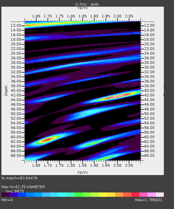
| Estimated Moho Depth: |
42.25 km |
| Estimated Crust Vp/Vs: |
2.00 |
| Assumed Crust Vp: |
6.1 km/s |
| Estimated Crust Vs: |
3.054 km/s |
| Estimated Crust Poisson's Ratio: |
0.33 |
|
| Radial Match: |
93.54479 % |
| Radial Bump: |
400 |
| Transverse Match: |
88.39428 % |
| Transverse Bump: |
400 |
| SOD ConfigId: |
2564 |
| Insert Time: |
2010-02-26 01:58:19.282 +0000 |
| GWidth: |
2.5 |
| Max Bumps: |
400 |
| Tol: |
0.001 |
|

Signal To Noise
| Channel | StoN | STA | LTA |
| CI:TOV: :BHN:20070113T04:33:24.560024Z | 1.3427387 | 7.362106E-7 | 5.482903E-7 |
| CI:TOV: :BHE:20070113T04:33:24.560024Z | 1.6462764 | 9.196887E-7 | 5.5864786E-7 |
| CI:TOV: :BHZ:20070113T04:33:24.560024Z | 5.4831114 | 2.6834682E-6 | 4.8940615E-7 |
| Arrivals |
| Ps | 7.1 SECOND |
| PpPs | 20 SECOND |
| PsPs/PpSs | 27 SECOND |


