You are here: Home > Network List > TA - USArray Transportable Network (new EarthScope stations) Stations List
> Station A21K Barrow, AK, USA > Earthquake Result Viewer
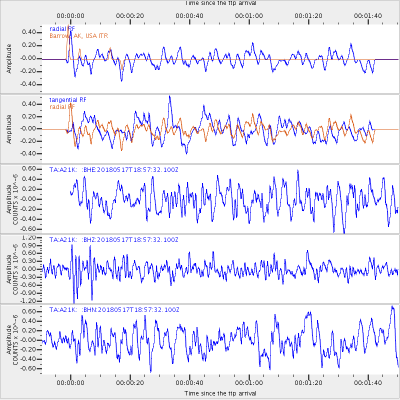
A21K Barrow, AK, USA - Earthquake Result Viewer
*The percent match for this event was below the threshold and hence no stack was calculated.
| Earthquake location: |
South Of Mariana Islands |
| Earthquake latitude/longitude: |
13.0/145.3 |
| Earthquake time(UTC): |
2018/05/17 (137) 18:47:09 GMT |
| Earthquake Depth: |
37 km |
| Earthquake Magnitude: |
5.5 mb |
| Earthquake Catalog/Contributor: |
NEIC PDE/us |
|
| Network: |
TA USArray Transportable Network (new EarthScope stations) |
| Station: |
A21K Barrow, AK, USA |
| Lat/Lon: |
71.32 N/156.62 W |
| Elevation: |
577 m |
|
| Distance: |
67.8 deg |
| Az: |
17.171 deg |
| Baz: |
243.273 deg |
| Ray Param: |
$rayparam |
*The percent match for this event was below the threshold and hence was not used in the summary stack. |
|
| Radial Match: |
54.74097 % |
| Radial Bump: |
400 |
| Transverse Match: |
63.74264 % |
| Transverse Bump: |
400 |
| SOD ConfigId: |
13570011 |
| Insert Time: |
2019-04-30 06:46:05.708 +0000 |
| GWidth: |
2.5 |
| Max Bumps: |
400 |
| Tol: |
0.001 |
|
Signal To Noise
| Channel | StoN | STA | LTA |
| TA:A21K: :BHZ:20180517T18:57:32.100Z | 2.6349642 | 5.2725517E-7 | 2.0009956E-7 |
| TA:A21K: :BHN:20180517T18:57:32.100Z | 1.4721195 | 2.3535313E-7 | 1.5987366E-7 |
| TA:A21K: :BHE:20180517T18:57:32.100Z | 0.9037654 | 1.7582614E-7 | 1.9454843E-7 |
| Arrivals |
| Ps | |
| PpPs | |
| PsPs/PpSs | |


