You are here: Home > Network List > TA - USArray Transportable Network (new EarthScope stations) Stations List
> Station C16K Lisburne Hills, AK, USA > Earthquake Result Viewer
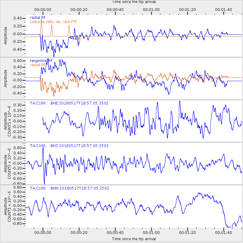
C16K Lisburne Hills, AK, USA - Earthquake Result Viewer
*The percent match for this event was below the threshold and hence no stack was calculated.
| Earthquake location: |
South Of Mariana Islands |
| Earthquake latitude/longitude: |
13.0/145.3 |
| Earthquake time(UTC): |
2018/05/17 (137) 18:47:09 GMT |
| Earthquake Depth: |
37 km |
| Earthquake Magnitude: |
5.5 mb |
| Earthquake Catalog/Contributor: |
NEIC PDE/us |
|
| Network: |
TA USArray Transportable Network (new EarthScope stations) |
| Station: |
C16K Lisburne Hills, AK, USA |
| Lat/Lon: |
68.27 N/165.34 W |
| Elevation: |
102 m |
|
| Distance: |
63.6 deg |
| Az: |
18.365 deg |
| Baz: |
235.577 deg |
| Ray Param: |
$rayparam |
*The percent match for this event was below the threshold and hence was not used in the summary stack. |
|
| Radial Match: |
62.719955 % |
| Radial Bump: |
400 |
| Transverse Match: |
48.357243 % |
| Transverse Bump: |
400 |
| SOD ConfigId: |
13570011 |
| Insert Time: |
2019-04-30 06:46:11.825 +0000 |
| GWidth: |
2.5 |
| Max Bumps: |
400 |
| Tol: |
0.001 |
|
Signal To Noise
| Channel | StoN | STA | LTA |
| TA:C16K: :BHZ:20180517T18:57:05.350Z | 3.5751348 | 3.3455407E-7 | 9.357803E-8 |
| TA:C16K: :BHN:20180517T18:57:05.350Z | 1.6497794 | 2.268032E-7 | 1.3747486E-7 |
| TA:C16K: :BHE:20180517T18:57:05.350Z | 0.9743529 | 1.07519725E-7 | 1.1034987E-7 |
| Arrivals |
| Ps | |
| PpPs | |
| PsPs/PpSs | |


