You are here: Home > Network List > TA - USArray Transportable Network (new EarthScope stations) Stations List
> Station D23K Nanushuk River, AK USA > Earthquake Result Viewer
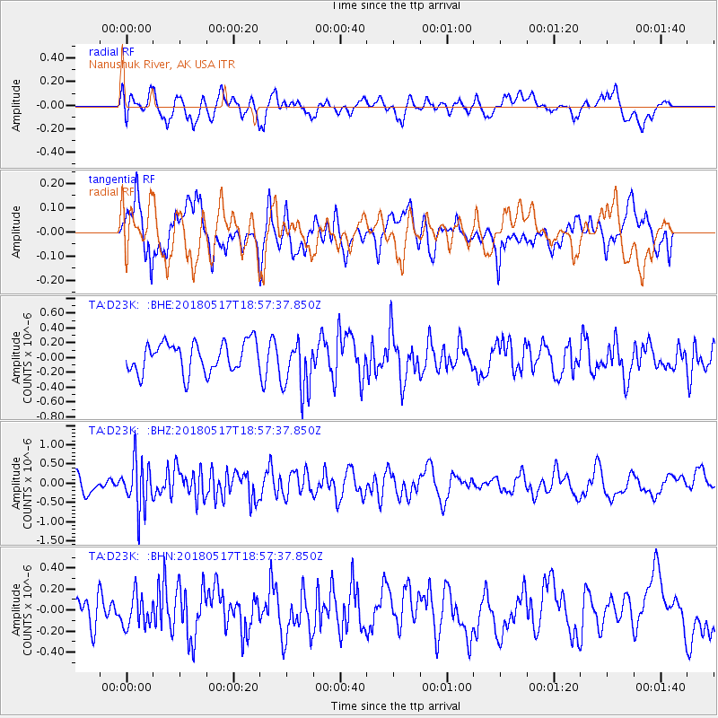
D23K Nanushuk River, AK USA - Earthquake Result Viewer
*The percent match for this event was below the threshold and hence no stack was calculated.
| Earthquake location: |
South Of Mariana Islands |
| Earthquake latitude/longitude: |
13.0/145.3 |
| Earthquake time(UTC): |
2018/05/17 (137) 18:47:09 GMT |
| Earthquake Depth: |
37 km |
| Earthquake Magnitude: |
5.5 mb |
| Earthquake Catalog/Contributor: |
NEIC PDE/us |
|
| Network: |
TA USArray Transportable Network (new EarthScope stations) |
| Station: |
D23K Nanushuk River, AK USA |
| Lat/Lon: |
68.97 N/150.68 W |
| Elevation: |
406 m |
|
| Distance: |
68.7 deg |
| Az: |
20.374 deg |
| Baz: |
250.041 deg |
| Ray Param: |
$rayparam |
*The percent match for this event was below the threshold and hence was not used in the summary stack. |
|
| Radial Match: |
62.642467 % |
| Radial Bump: |
400 |
| Transverse Match: |
62.9183 % |
| Transverse Bump: |
400 |
| SOD ConfigId: |
13570011 |
| Insert Time: |
2019-04-30 06:46:19.431 +0000 |
| GWidth: |
2.5 |
| Max Bumps: |
400 |
| Tol: |
0.001 |
|
Signal To Noise
| Channel | StoN | STA | LTA |
| TA:D23K: :BHZ:20180517T18:57:37.850Z | 3.0777323 | 6.393569E-7 | 2.0773638E-7 |
| TA:D23K: :BHN:20180517T18:57:37.850Z | 1.0521253 | 1.5136177E-7 | 1.4386288E-7 |
| TA:D23K: :BHE:20180517T18:57:37.850Z | 1.6531364 | 3.3844486E-7 | 2.0472893E-7 |
| Arrivals |
| Ps | |
| PpPs | |
| PsPs/PpSs | |


