You are here: Home > Network List > TA - USArray Transportable Network (new EarthScope stations) Stations List
> Station D25K Kavik River, AK, USA > Earthquake Result Viewer
D25K Kavik River, AK, USA - Earthquake Result Viewer
*The percent match for this event was below the threshold and hence no stack was calculated.
| Earthquake location: |
South Of Mariana Islands |
| Earthquake latitude/longitude: |
13.0/145.3 |
| Earthquake time(UTC): |
2018/05/17 (137) 18:47:09 GMT |
| Earthquake Depth: |
37 km |
| Earthquake Magnitude: |
5.5 mb |
| Earthquake Catalog/Contributor: |
NEIC PDE/us |
|
| Network: |
TA USArray Transportable Network (new EarthScope stations) |
| Station: |
D25K Kavik River, AK, USA |
| Lat/Lon: |
69.32 N/146.38 W |
| Elevation: |
770 m |
|
| Distance: |
70.3 deg |
| Az: |
20.517 deg |
| Baz: |
254.111 deg |
| Ray Param: |
$rayparam |
*The percent match for this event was below the threshold and hence was not used in the summary stack. |
|
| Radial Match: |
49.970776 % |
| Radial Bump: |
400 |
| Transverse Match: |
62.037407 % |
| Transverse Bump: |
400 |
| SOD ConfigId: |
13570011 |
| Insert Time: |
2019-04-30 06:46:20.047 +0000 |
| GWidth: |
2.5 |
| Max Bumps: |
400 |
| Tol: |
0.001 |
|
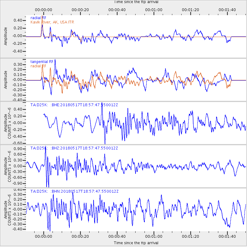
Signal To Noise
| Channel | StoN | STA | LTA |
| TA:D25K: :BHZ:20180517T18:57:47.550012Z | 4.0189095 | 4.741806E-7 | 1.1798738E-7 |
| TA:D25K: :BHN:20180517T18:57:47.550012Z | 1.3474395 | 1.7594228E-7 | 1.3057527E-7 |
| TA:D25K: :BHE:20180517T18:57:47.550012Z | 1.7346259 | 2.5527234E-7 | 1.4716277E-7 |
| Arrivals |
| Ps | |
| PpPs | |
| PsPs/PpSs | |


