You are here: Home > Network List > TA - USArray Transportable Network (new EarthScope stations) Stations List
> Station G31M Satah River, YT, CAN > Earthquake Result Viewer
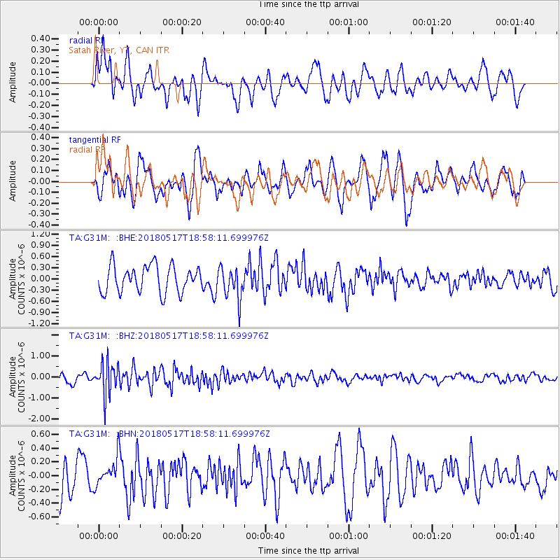
G31M Satah River, YT, CAN - Earthquake Result Viewer
*The percent match for this event was below the threshold and hence no stack was calculated.
| Earthquake location: |
South Of Mariana Islands |
| Earthquake latitude/longitude: |
13.0/145.3 |
| Earthquake time(UTC): |
2018/05/17 (137) 18:47:09 GMT |
| Earthquake Depth: |
37 km |
| Earthquake Magnitude: |
5.5 mb |
| Earthquake Catalog/Contributor: |
NEIC PDE/us |
|
| Network: |
TA USArray Transportable Network (new EarthScope stations) |
| Station: |
G31M Satah River, YT, CAN |
| Lat/Lon: |
66.92 N/134.27 W |
| Elevation: |
61 m |
|
| Distance: |
74.4 deg |
| Az: |
23.804 deg |
| Baz: |
266.339 deg |
| Ray Param: |
$rayparam |
*The percent match for this event was below the threshold and hence was not used in the summary stack. |
|
| Radial Match: |
38.841084 % |
| Radial Bump: |
343 |
| Transverse Match: |
66.50716 % |
| Transverse Bump: |
345 |
| SOD ConfigId: |
13570011 |
| Insert Time: |
2019-04-30 06:46:44.580 +0000 |
| GWidth: |
2.5 |
| Max Bumps: |
400 |
| Tol: |
0.001 |
|
Signal To Noise
| Channel | StoN | STA | LTA |
| TA:G31M: :BHZ:20180517T18:58:11.699976Z | 4.561967 | 7.7771267E-7 | 1.7047748E-7 |
| TA:G31M: :BHN:20180517T18:58:11.699976Z | 0.65630925 | 2.03466E-7 | 3.1001545E-7 |
| TA:G31M: :BHE:20180517T18:58:11.699976Z | 1.1891724 | 4.2500116E-7 | 3.573924E-7 |
| Arrivals |
| Ps | |
| PpPs | |
| PsPs/PpSs | |


