You are here: Home > Network List > US - United States National Seismic Network Stations List
> Station AAM Ann Arbor, Michigan, USA > Earthquake Result Viewer
AAM Ann Arbor, Michigan, USA - Earthquake Result Viewer

| Earthquake location: |
Near Coast Of Ecuador |
| Earthquake latitude/longitude: |
0.5/-79.6 |
| Earthquake time(UTC): |
2016/05/18 (139) 16:46:44 GMT |
| Earthquake Depth: |
31 km |
| Earthquake Magnitude: |
6.8 MO |
| Earthquake Catalog/Contributor: |
NEIC PDE/NEIC ALERT |
|
| Network: |
US United States National Seismic Network |
| Station: |
AAM Ann Arbor, Michigan, USA |
| Lat/Lon: |
42.30 N/83.66 W |
| Elevation: |
172 m |
|
| Distance: |
41.8 deg |
| Az: |
355.53 deg |
| Baz: |
173.969 deg |
| Ray Param: |
0.07349756 |
| Estimated Moho Depth: |
49.5 km |
| Estimated Crust Vp/Vs: |
1.75 |
| Assumed Crust Vp: |
6.483 km/s |
| Estimated Crust Vs: |
3.699 km/s |
| Estimated Crust Poisson's Ratio: |
0.26 |
|
| Radial Match: |
94.48168 % |
| Radial Bump: |
400 |
| Transverse Match: |
78.90361 % |
| Transverse Bump: |
400 |
| SOD ConfigId: |
1475611 |
| Insert Time: |
2016-06-01 16:56:48.336 +0000 |
| GWidth: |
2.5 |
| Max Bumps: |
400 |
| Tol: |
0.001 |
|
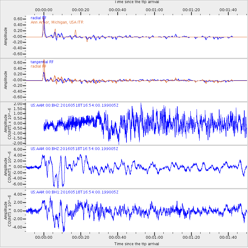
Signal To Noise
| Channel | StoN | STA | LTA |
| US:AAM:00:BHZ:20160518T16:54:00.199005Z | 12.392654 | 2.5238287E-6 | 2.036552E-7 |
| US:AAM:00:BH1:20160518T16:54:00.199005Z | 4.946344 | 1.7269947E-6 | 3.4914572E-7 |
| US:AAM:00:BH2:20160518T16:54:00.199005Z | 1.7431844 | 6.403444E-7 | 3.6734176E-7 |
| Arrivals |
| Ps | 6.2 SECOND |
| PpPs | 20 SECOND |
| PsPs/PpSs | 26 SECOND |


