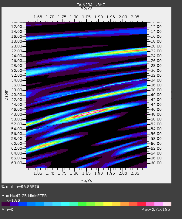
N23A Red Feather Lakes, CO, USA - Earthquake Result Viewer
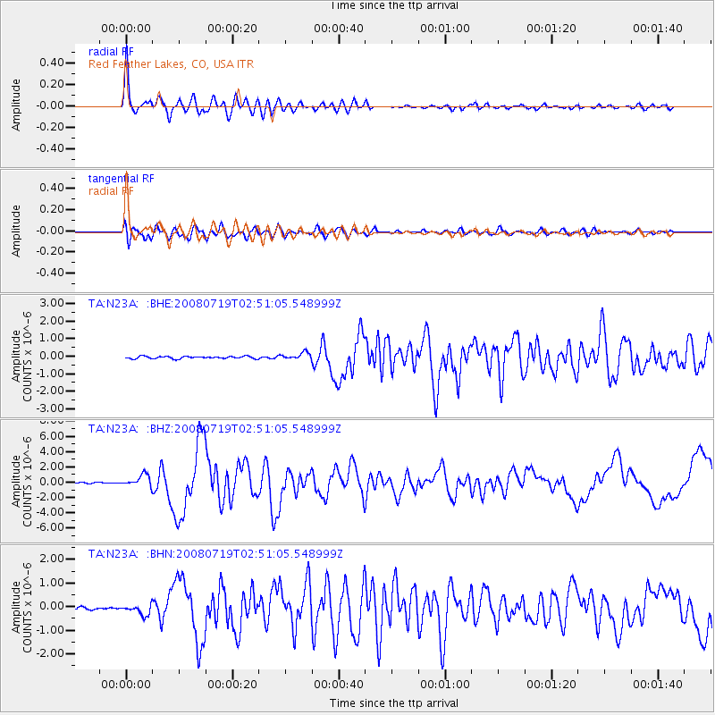
Earthquake location: Off East Coast Of Honshu, Japan
Earthquake latitude/longitude: 37.6/142.2
Earthquake time(UTC): 2008/07/19 (201) 02:39:28 GMT
Earthquake Depth: 22 km
Earthquake Magnitude: 6.2 MB, 7.0 MS, 7.0 MW, 6.9 MW
Earthquake Catalog/Contributor: WHDF/NEIC
Network: TA USArray Transportable Network (new EarthScope stations)
Station: N23A Red Feather Lakes, CO, USA
Lat/Lon: 40.89 N/105.94 W
Elevation: 2458 m
Distance: 80.1 deg
Az: 45.583 deg
Baz: 311.511 deg
Ray Param: 0.048473693
Estimated Moho Depth: 47.25 km
Estimated Crust Vp/Vs: 1.86
Assumed Crust Vp: 6.306 km/s
Estimated Crust Vs: 3.39 km/s
Estimated Crust Poisson's Ratio: 0.30
Radial Match: 95.86876 %
Radial Bump: 400
Transverse Match: 88.80505 %
Transverse Bump: 400
SOD ConfigId: 2504
Insert Time: 2010-03-06 11:18:05.222 +0000
GWidth: 2.5
Max Bumps: 400
Tol: 0.001

Signal To Noise

ChannelStoNSTALTA
TA:N23A: :BHZ:20080719T02:51:05.548999Z10.7552327.706653E-77.165492E-8
TA:N23A: :BHN:20080719T02:51:05.548999Z3.74380762.1823986E-75.829356E-8
TA:N23A: :BHE:20080719T02:51:05.548999Z2.9518691.9749287E-76.690435E-8
Arrivals
Ps6.6 SECOND
PpPs21 SECOND
PsPs/PpSs27 SECOND