You are here: Home > Network List > CI - Caltech Regional Seismic Network Stations List
> Station TOV Thousand Oaks, California, USA > Earthquake Result Viewer
TOV Thousand Oaks, California, USA - Earthquake Result Viewer
| Earthquake location: |
South Of Fiji Islands |
| Earthquake latitude/longitude: |
-22.1/-176.8 |
| Earthquake time(UTC): |
1997/10/14 (287) 09:53:18 GMT |
| Earthquake Depth: |
167 km |
| Earthquake Magnitude: |
6.7 MB, 7.7 UNKNOWN, 7.4 ME |
| Earthquake Catalog/Contributor: |
WHDF/NEIC |
|
| Network: |
CI Caltech Regional Seismic Network |
| Station: |
TOV Thousand Oaks, California, USA |
| Lat/Lon: |
34.16 N/118.82 W |
| Elevation: |
50 m |
|
| Distance: |
78.5 deg |
| Az: |
45.827 deg |
| Baz: |
233.333 deg |
| Ray Param: |
0.049175218 |
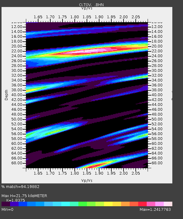
| Estimated Moho Depth: |
21.75 km |
| Estimated Crust Vp/Vs: |
1.84 |
| Assumed Crust Vp: |
6.1 km/s |
| Estimated Crust Vs: |
3.32 km/s |
| Estimated Crust Poisson's Ratio: |
0.29 |
|
| Radial Match: |
94.19882 % |
| Radial Bump: |
400 |
| Transverse Match: |
85.955505 % |
| Transverse Bump: |
400 |
| SOD ConfigId: |
6273 |
| Insert Time: |
2010-02-26 01:58:25.316 +0000 |
| GWidth: |
2.5 |
| Max Bumps: |
400 |
| Tol: |
0.001 |
|
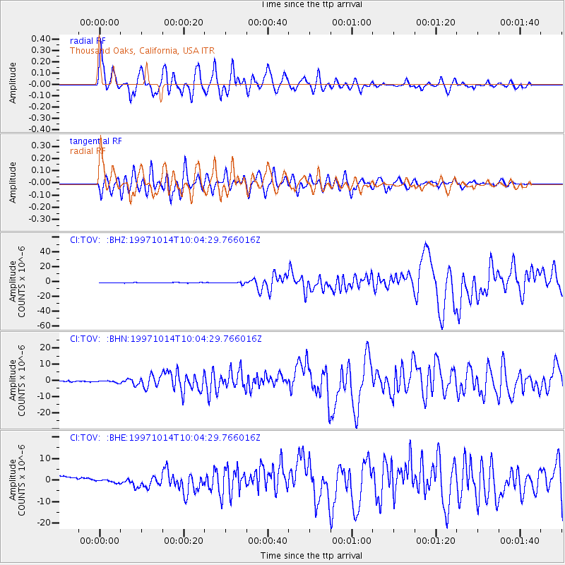
Signal To Noise
| Channel | StoN | STA | LTA |
| CI:TOV: :BHN:19971014T10:04:29.766016Z | 1.721375 | 6.1950817E-7 | 3.5989146E-7 |
| CI:TOV: :BHE:19971014T10:04:29.766016Z | 0.5527683 | 8.45892E-7 | 1.5302832E-6 |
| CI:TOV: :BHZ:19971014T10:04:29.766016Z | 4.100071 | 1.1696636E-6 | 2.852789E-7 |
| Arrivals |
| Ps | 3.1 SECOND |
| PpPs | 9.9 SECOND |
| PsPs/PpSs | 13 SECOND |


