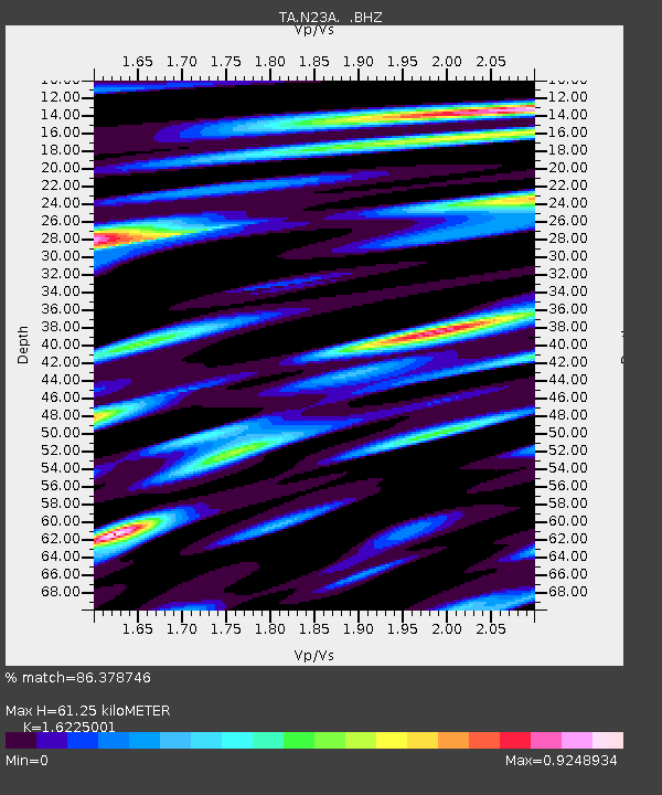
N23A Red Feather Lakes, CO, USA - Earthquake Result Viewer
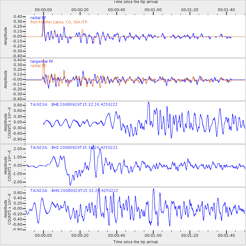
Earthquake location: Kermadec Islands, New Zealand
Earthquake latitude/longitude: -29.8/-177.7
Earthquake time(UTC): 2008/09/29 (273) 15:19:31 GMT
Earthquake Depth: 36 km
Earthquake Magnitude: 6.5 MB, 6.7 MS, 7.0 MW, 7.0 MW
Earthquake Catalog/Contributor: WHDF/NEIC
Network: TA USArray Transportable Network (new EarthScope stations)
Station: N23A Red Feather Lakes, CO, USA
Lat/Lon: 40.89 N/105.94 W
Elevation: 2458 m
Distance: 96.6 deg
Az: 46.448 deg
Baz: 236.237 deg
Ray Param: 0.04043899
Estimated Moho Depth: 61.25 km
Estimated Crust Vp/Vs: 1.62
Assumed Crust Vp: 6.306 km/s
Estimated Crust Vs: 3.887 km/s
Estimated Crust Poisson's Ratio: 0.19
Radial Match: 86.378746 %
Radial Bump: 400
Transverse Match: 67.345345 %
Transverse Bump: 400
SOD ConfigId: 2560
Insert Time: 2010-03-06 11:18:32.454 +0000
GWidth: 2.5
Max Bumps: 400
Tol: 0.001

Signal To Noise

ChannelStoNSTALTA
TA:N23A: :BHZ:20080929T15:32:26.425022Z2.9630772.901197E-79.791162E-8
TA:N23A: :BHN:20080929T15:32:26.425022Z1.47046792.0041134E-71.3629086E-7
TA:N23A: :BHE:20080929T15:32:26.425022Z1.06444821.2436374E-71.1683399E-7
Arrivals
Ps6.2 SECOND
PpPs25 SECOND
PsPs/PpSs31 SECOND