You are here: Home > Network List > AZ - ANZA Regional Network Stations List
> Station SMER AZ.SMER > Earthquake Result Viewer
SMER AZ.SMER - Earthquake Result Viewer
*The percent match for this event was below the threshold and hence no stack was calculated.
| Earthquake location: |
South Of Kermadec Islands |
| Earthquake latitude/longitude: |
-34.6/-178.4 |
| Earthquake time(UTC): |
2018/05/18 (138) 01:45:31 GMT |
| Earthquake Depth: |
11 km |
| Earthquake Magnitude: |
6.2 Mww |
| Earthquake Catalog/Contributor: |
NEIC PDE/us |
|
| Network: |
AZ ANZA Regional Network |
| Station: |
SMER AZ.SMER |
| Lat/Lon: |
33.46 N/117.17 W |
| Elevation: |
355 m |
|
| Distance: |
88.7 deg |
| Az: |
47.145 deg |
| Baz: |
226.368 deg |
| Ray Param: |
$rayparam |
*The percent match for this event was below the threshold and hence was not used in the summary stack. |
|
| Radial Match: |
22.004917 % |
| Radial Bump: |
400 |
| Transverse Match: |
26.102749 % |
| Transverse Bump: |
400 |
| SOD ConfigId: |
13570011 |
| Insert Time: |
2019-04-30 06:54:41.658 +0000 |
| GWidth: |
2.5 |
| Max Bumps: |
400 |
| Tol: |
0.001 |
|
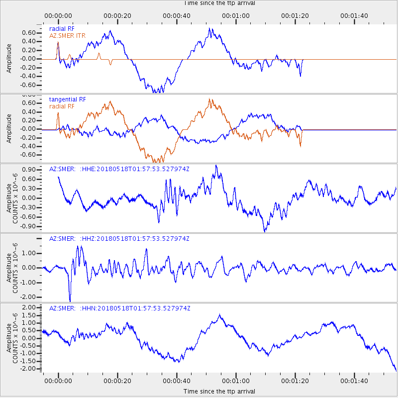
Signal To Noise
| Channel | StoN | STA | LTA |
| AZ:SMER: :HHZ:20180518T01:57:53.527974Z | 10.468517 | 7.01501E-7 | 6.701054E-8 |
| AZ:SMER: :HHN:20180518T01:57:53.527974Z | 1.1894011 | 6.131479E-7 | 5.155097E-7 |
| AZ:SMER: :HHE:20180518T01:57:53.527974Z | 1.3221416 | 2.741603E-7 | 2.0736077E-7 |
| Arrivals |
| Ps | |
| PpPs | |
| PsPs/PpSs | |


