You are here: Home > Network List > TA - USArray Transportable Network (new EarthScope stations) Stations List
> Station N23A Red Feather Lakes, CO, USA > Earthquake Result Viewer
N23A Red Feather Lakes, CO, USA - Earthquake Result Viewer
| Earthquake location: |
Kermadec Islands Region |
| Earthquake latitude/longitude: |
-27.4/-176.3 |
| Earthquake time(UTC): |
2009/02/18 (049) 21:53:45 GMT |
| Earthquake Depth: |
25 km |
| Earthquake Magnitude: |
6.8 MB, 7.2 MS, 6.9 MW, 6.9 MW |
| Earthquake Catalog/Contributor: |
WHDF/NEIC |
|
| Network: |
TA USArray Transportable Network (new EarthScope stations) |
| Station: |
N23A Red Feather Lakes, CO, USA |
| Lat/Lon: |
40.89 N/105.94 W |
| Elevation: |
2458 m |
|
| Distance: |
94.2 deg |
| Az: |
45.724 deg |
| Baz: |
237.089 deg |
| Ray Param: |
0.041099958 |
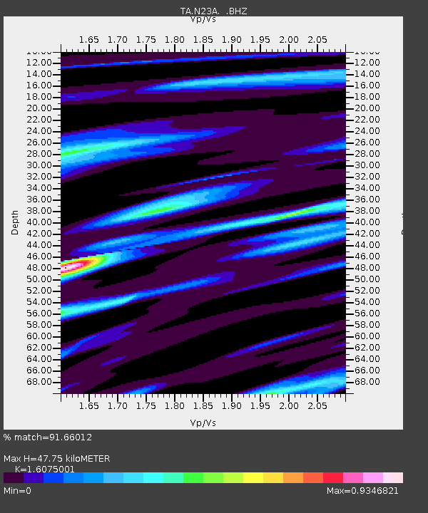
| Estimated Moho Depth: |
47.75 km |
| Estimated Crust Vp/Vs: |
1.61 |
| Assumed Crust Vp: |
6.306 km/s |
| Estimated Crust Vs: |
3.923 km/s |
| Estimated Crust Poisson's Ratio: |
0.18 |
|
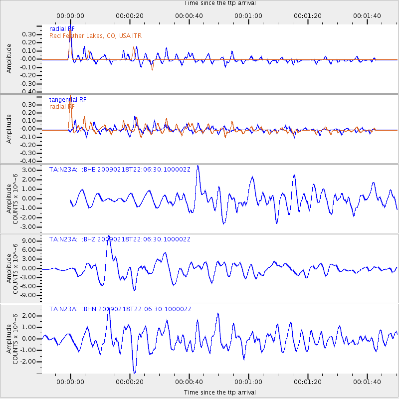
| Radial Match: |
91.66012 % |
| Radial Bump: |
309 |
| Transverse Match: |
74.14265 % |
| Transverse Bump: |
297 |
| SOD ConfigId: |
2658 |
| Insert Time: |
2010-03-06 11:19:11.527 +0000 |
| GWidth: |
2.5 |
| Max Bumps: |
400 |
| Tol: |
0.001 |
|
Signal To Noise
| Channel | StoN | STA | LTA |
| TA:N23A: :BHZ:20090218T22:06:30.100002Z | 7.469714 | 1.2134205E-6 | 1.6244537E-7 |
| TA:N23A: :BHN:20090218T22:06:30.100002Z | 1.4865202 | 5.335828E-7 | 3.5894755E-7 |
| TA:N23A: :BHE:20090218T22:06:30.100002Z | 1.0310245 | 4.698901E-7 | 4.5575064E-7 |
| Arrivals |
| Ps | 4.7 SECOND |
| PpPs | 19 SECOND |
| PsPs/PpSs | 24 SECOND |


