You are here: Home > Network List > CI - Caltech Regional Seismic Network Stations List
> Station LRL Laurel Mtn Radio Fac, Ridgecrest, CA, USA > Earthquake Result Viewer
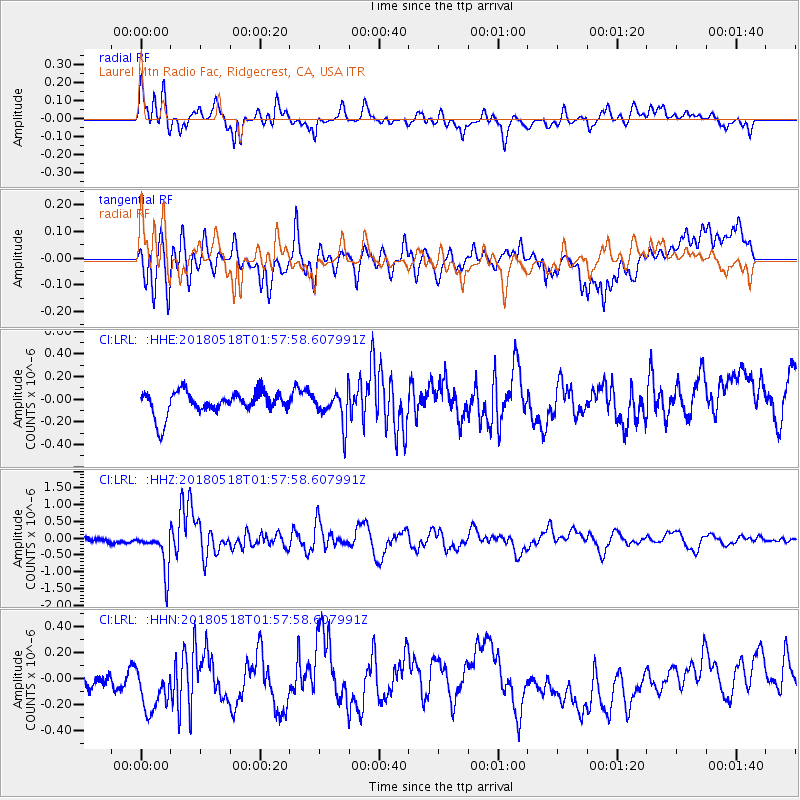
LRL Laurel Mtn Radio Fac, Ridgecrest, CA, USA - Earthquake Result Viewer
*The percent match for this event was below the threshold and hence no stack was calculated.
| Earthquake location: |
South Of Kermadec Islands |
| Earthquake latitude/longitude: |
-34.6/-178.4 |
| Earthquake time(UTC): |
2018/05/18 (138) 01:45:31 GMT |
| Earthquake Depth: |
11 km |
| Earthquake Magnitude: |
6.2 Mww |
| Earthquake Catalog/Contributor: |
NEIC PDE/us |
|
| Network: |
CI Caltech Regional Seismic Network |
| Station: |
LRL Laurel Mtn Radio Fac, Ridgecrest, CA, USA |
| Lat/Lon: |
35.48 N/117.68 W |
| Elevation: |
1340 m |
|
| Distance: |
89.8 deg |
| Az: |
45.397 deg |
| Baz: |
226.058 deg |
| Ray Param: |
$rayparam |
*The percent match for this event was below the threshold and hence was not used in the summary stack. |
|
| Radial Match: |
76.61502 % |
| Radial Bump: |
400 |
| Transverse Match: |
63.615883 % |
| Transverse Bump: |
400 |
| SOD ConfigId: |
13570011 |
| Insert Time: |
2019-04-30 06:55:59.682 +0000 |
| GWidth: |
2.5 |
| Max Bumps: |
400 |
| Tol: |
0.001 |
|
Signal To Noise
| Channel | StoN | STA | LTA |
| CI:LRL: :HHZ:20180518T01:57:58.607991Z | 6.323317 | 6.203126E-7 | 9.809924E-8 |
| CI:LRL: :HHN:20180518T01:57:58.607991Z | 2.3246415 | 2.2135583E-7 | 9.5221495E-8 |
| CI:LRL: :HHE:20180518T01:57:58.607991Z | 1.4087687 | 1.4521478E-7 | 1.0307922E-7 |
| Arrivals |
| Ps | |
| PpPs | |
| PsPs/PpSs | |


