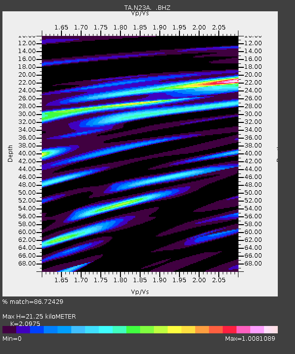
N23A Red Feather Lakes, CO, USA - Earthquake Result Viewer
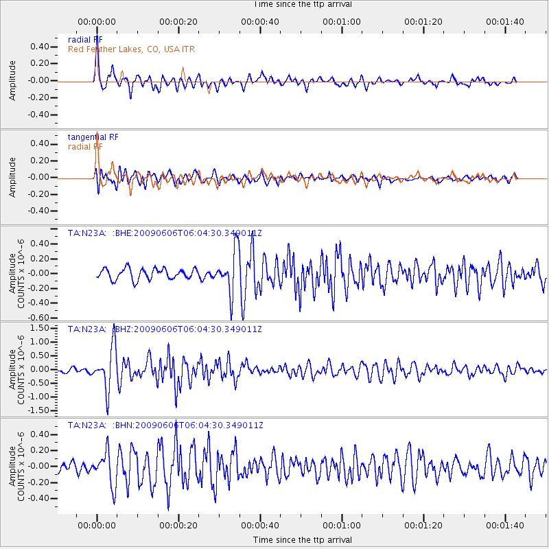
Earthquake location: Near East Coast Of Honshu, Japan
Earthquake latitude/longitude: 35.5/140.9
Earthquake time(UTC): 2009/06/06 (157) 05:52:43 GMT
Earthquake Depth: 34 km
Earthquake Magnitude: 5.8 MB, 5.4 MS, 5.8 MW, 5.7 MW
Earthquake Catalog/Contributor: WHDF/NEIC
Network: TA USArray Transportable Network (new EarthScope stations)
Station: N23A Red Feather Lakes, CO, USA
Lat/Lon: 40.89 N/105.94 W
Elevation: 2458 m
Distance: 82.3 deg
Az: 44.701 deg
Baz: 310.777 deg
Ray Param: 0.046926033
Estimated Moho Depth: 21.25 km
Estimated Crust Vp/Vs: 2.10
Assumed Crust Vp: 6.306 km/s
Estimated Crust Vs: 3.006 km/s
Estimated Crust Poisson's Ratio: 0.35
Radial Match: 86.72429 %
Radial Bump: 400
Transverse Match: 76.541245 %
Transverse Bump: 400
SOD ConfigId: 2648
Insert Time: 2010-03-06 11:19:17.102 +0000
GWidth: 2.5
Max Bumps: 400
Tol: 0.001

Signal To Noise

ChannelStoNSTALTA
TA:N23A: :BHZ:20090606T06:04:30.349011Z11.0452537.9585203E-77.2053766E-8
TA:N23A: :BHN:20090606T06:04:30.349011Z2.9237832.1367585E-77.308198E-8
TA:N23A: :BHE:20090606T06:04:30.349011Z4.05072072.9387542E-77.254893E-8
Arrivals
Ps3.8 SECOND
PpPs10 SECOND
PsPs/PpSs14 SECOND