You are here: Home > Network List > CI - Caltech Regional Seismic Network Stations List
> Station MPP McPhearson Peak > Earthquake Result Viewer
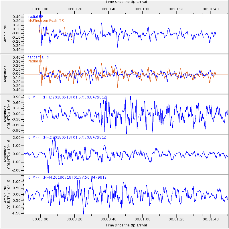
MPP McPhearson Peak - Earthquake Result Viewer
*The percent match for this event was below the threshold and hence no stack was calculated.
| Earthquake location: |
South Of Kermadec Islands |
| Earthquake latitude/longitude: |
-34.6/-178.4 |
| Earthquake time(UTC): |
2018/05/18 (138) 01:45:31 GMT |
| Earthquake Depth: |
11 km |
| Earthquake Magnitude: |
6.2 Mww |
| Earthquake Catalog/Contributor: |
NEIC PDE/us |
|
| Network: |
CI Caltech Regional Seismic Network |
| Station: |
MPP McPhearson Peak |
| Lat/Lon: |
34.89 N/119.81 W |
| Elevation: |
1739 m |
|
| Distance: |
88.2 deg |
| Az: |
44.592 deg |
| Baz: |
224.821 deg |
| Ray Param: |
$rayparam |
*The percent match for this event was below the threshold and hence was not used in the summary stack. |
|
| Radial Match: |
62.96469 % |
| Radial Bump: |
400 |
| Transverse Match: |
51.272594 % |
| Transverse Bump: |
400 |
| SOD ConfigId: |
13570011 |
| Insert Time: |
2019-04-30 06:56:02.760 +0000 |
| GWidth: |
2.5 |
| Max Bumps: |
400 |
| Tol: |
0.001 |
|
Signal To Noise
| Channel | StoN | STA | LTA |
| CI:MPP: :HHZ:20180518T01:57:50.847981Z | 4.363695 | 7.383265E-7 | 1.6919755E-7 |
| CI:MPP: :HHN:20180518T01:57:50.847981Z | 1.0589169 | 3.2289594E-7 | 3.0493038E-7 |
| CI:MPP: :HHE:20180518T01:57:50.847981Z | 1.1311358 | 2.3570583E-7 | 2.0837979E-7 |
| Arrivals |
| Ps | |
| PpPs | |
| PsPs/PpSs | |


