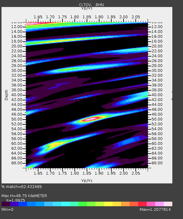
TOV Thousand Oaks, California, USA - Earthquake Result Viewer
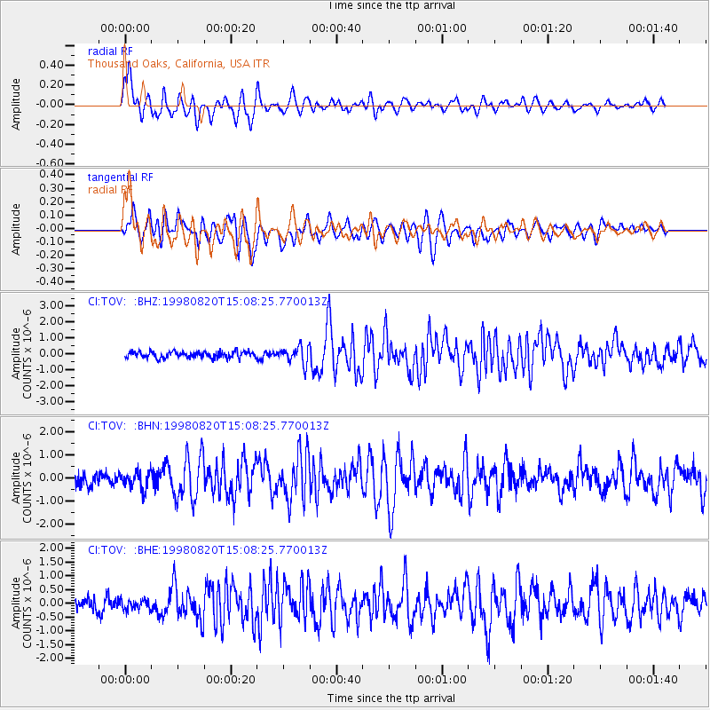
Earthquake location: Rat Islands, Aleutian Islands
Earthquake latitude/longitude: 51.6/175.2
Earthquake time(UTC): 1998/08/20 (232) 15:00:08 GMT
Earthquake Depth: 33 km
Earthquake Magnitude: 5.6 MB, 6.0 MS, 6.2 UNKNOWN, 6.2 MW
Earthquake Catalog/Contributor: WHDF/NEIC
Network: CI Caltech Regional Seismic Network
Station: TOV Thousand Oaks, California, USA
Lat/Lon: 34.16 N/118.82 W
Elevation: 50 m
Distance: 49.6 deg
Az: 83.667 deg
Baz: 311.648 deg
Ray Param: 0.06851945
Estimated Moho Depth: 49.75 km
Estimated Crust Vp/Vs: 1.86
Assumed Crust Vp: 6.1 km/s
Estimated Crust Vs: 3.275 km/s
Estimated Crust Poisson's Ratio: 0.30
Radial Match: 82.432465 %
Radial Bump: 400
Transverse Match: 83.56652 %
Transverse Bump: 400
SOD ConfigId: 4770
Insert Time: 2010-02-26 01:58:28.423 +0000
GWidth: 2.5
Max Bumps: 400
Tol: 0.001

Signal To Noise

ChannelStoNSTALTA
CI:TOV: :BHN:19980820T15:08:25.770013Z1.35526083.7858678E-72.7934604E-7
CI:TOV: :BHE:19980820T15:08:25.770013Z0.82426571.828232E-72.218013E-7
CI:TOV: :BHZ:19980820T15:08:25.770013Z2.85023715.5105244E-71.9333565E-7
Arrivals
Ps7.4 SECOND
PpPs22 SECOND
PsPs/PpSs30 SECOND