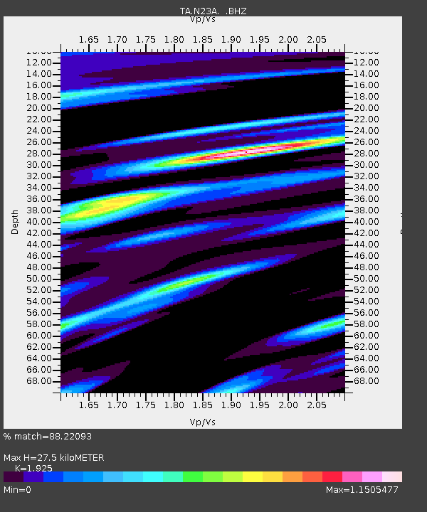
N23A Red Feather Lakes, CO, USA - Earthquake Result Viewer
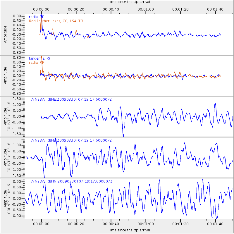
Earthquake location: Kodiak Island Region, Alaska
Earthquake latitude/longitude: 56.5/-152.7
Earthquake time(UTC): 2009/03/30 (089) 07:13:07 GMT
Earthquake Depth: 21 km
Earthquake Magnitude: 5.9 MB, 5.9 MS, 5.9 MW, 5.9 MW
Earthquake Catalog/Contributor: WHDF/NEIC
Network: TA USArray Transportable Network (new EarthScope stations)
Station: N23A Red Feather Lakes, CO, USA
Lat/Lon: 40.89 N/105.94 W
Elevation: 2458 m
Distance: 33.9 deg
Az: 97.311 deg
Baz: 313.561 deg
Ray Param: 0.077990465
Estimated Moho Depth: 27.5 km
Estimated Crust Vp/Vs: 1.92
Assumed Crust Vp: 6.306 km/s
Estimated Crust Vs: 3.276 km/s
Estimated Crust Poisson's Ratio: 0.32
Radial Match: 88.22093 %
Radial Bump: 400
Transverse Match: 54.06896 %
Transverse Bump: 400
SOD ConfigId: 2658
Insert Time: 2010-03-06 11:19:36.930 +0000
GWidth: 2.5
Max Bumps: 400
Tol: 0.001

Signal To Noise

ChannelStoNSTALTA
TA:N23A: :BHZ:20090330T07:19:17.600007Z7.1390367.728913E-71.08262704E-7
TA:N23A: :BHN:20090330T07:19:17.600007Z3.0599875.2209083E-71.7061865E-7
TA:N23A: :BHE:20090330T07:19:17.600007Z3.00723084.6333582E-71.5407392E-7
Arrivals
Ps4.3 SECOND
PpPs12 SECOND
PsPs/PpSs16 SECOND