You are here: Home > Network List > NN - Western Great Basin/Eastern Sierra Nevada Stations List
> Station TBRD Thunderbird Lodge, Lake Tahoe, NV > Earthquake Result Viewer
TBRD Thunderbird Lodge, Lake Tahoe, NV - Earthquake Result Viewer
| Earthquake location: |
South Of Kermadec Islands |
| Earthquake latitude/longitude: |
-34.6/-178.4 |
| Earthquake time(UTC): |
2018/05/18 (138) 01:45:31 GMT |
| Earthquake Depth: |
11 km |
| Earthquake Magnitude: |
6.2 Mww |
| Earthquake Catalog/Contributor: |
NEIC PDE/us |
|
| Network: |
NN Western Great Basin/Eastern Sierra Nevada |
| Station: |
TBRD Thunderbird Lodge, Lake Tahoe, NV |
| Lat/Lon: |
39.17 N/119.93 W |
| Elevation: |
1952 m |
|
| Distance: |
91.1 deg |
| Az: |
41.513 deg |
| Baz: |
224.732 deg |
| Ray Param: |
0.041623592 |
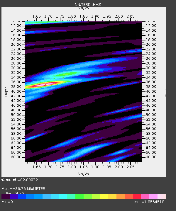
| Estimated Moho Depth: |
36.75 km |
| Estimated Crust Vp/Vs: |
1.69 |
| Assumed Crust Vp: |
6.279 km/s |
| Estimated Crust Vs: |
3.721 km/s |
| Estimated Crust Poisson's Ratio: |
0.23 |
|
| Radial Match: |
82.89072 % |
| Radial Bump: |
400 |
| Transverse Match: |
63.583755 % |
| Transverse Bump: |
400 |
| SOD ConfigId: |
13570011 |
| Insert Time: |
2019-04-30 06:57:26.226 +0000 |
| GWidth: |
2.5 |
| Max Bumps: |
400 |
| Tol: |
0.001 |
|

Signal To Noise
| Channel | StoN | STA | LTA |
| NN:TBRD: :HHZ:20180518T01:58:04.698018Z | 7.365543 | 1.2040374E-5 | 1.6346892E-6 |
| NN:TBRD: :HHN:20180518T01:58:04.698018Z | 2.745548 | 4.485885E-6 | 1.6338759E-6 |
| NN:TBRD: :HHE:20180518T01:58:04.698018Z | 1.3773248 | 2.878329E-6 | 2.089797E-6 |
| Arrivals |
| Ps | 4.1 SECOND |
| PpPs | 15 SECOND |
| PsPs/PpSs | 20 SECOND |


