You are here: Home > Network List > TA - USArray Transportable Network (new EarthScope stations) Stations List
> Station E20K Nigu River, AK, USA > Earthquake Result Viewer
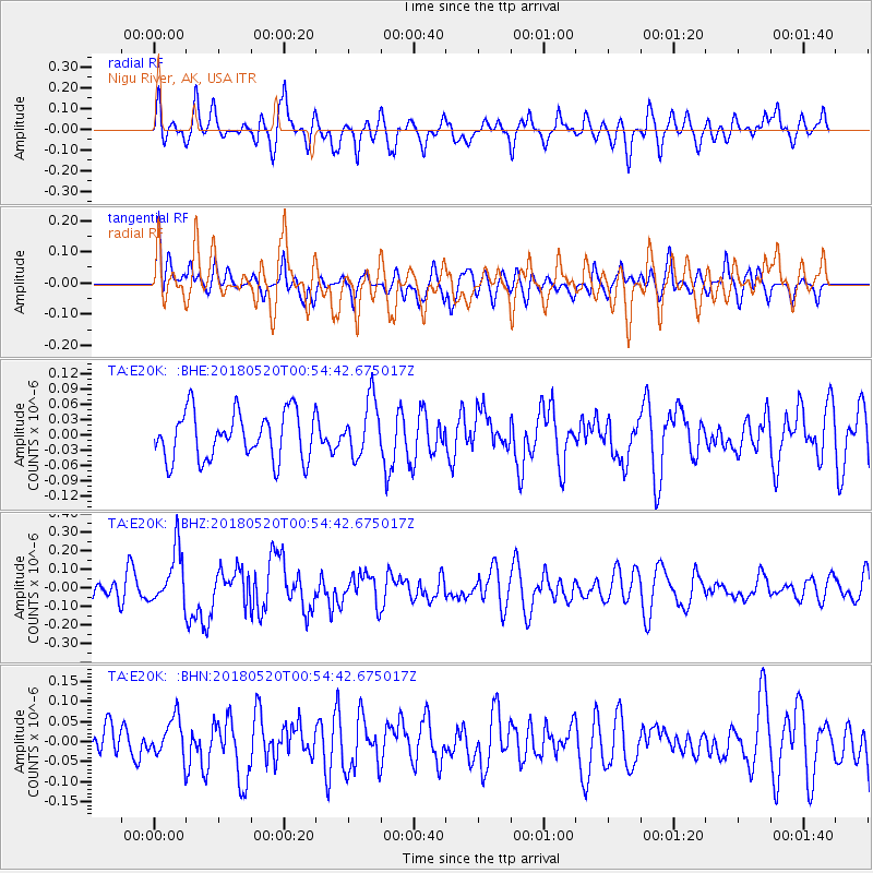
E20K Nigu River, AK, USA - Earthquake Result Viewer
*The percent match for this event was below the threshold and hence no stack was calculated.
| Earthquake location: |
Tonga Islands |
| Earthquake latitude/longitude: |
-21.0/-174.0 |
| Earthquake time(UTC): |
2018/05/20 (140) 00:42:14 GMT |
| Earthquake Depth: |
10 km |
| Earthquake Magnitude: |
5.5 Mww |
| Earthquake Catalog/Contributor: |
NEIC PDE/us |
|
| Network: |
TA USArray Transportable Network (new EarthScope stations) |
| Station: |
E20K Nigu River, AK, USA |
| Lat/Lon: |
68.26 N/156.19 W |
| Elevation: |
866 m |
|
| Distance: |
89.9 deg |
| Az: |
6.545 deg |
| Baz: |
196.612 deg |
| Ray Param: |
$rayparam |
*The percent match for this event was below the threshold and hence was not used in the summary stack. |
|
| Radial Match: |
64.50409 % |
| Radial Bump: |
400 |
| Transverse Match: |
53.209293 % |
| Transverse Bump: |
400 |
| SOD ConfigId: |
13570011 |
| Insert Time: |
2019-04-30 07:05:39.714 +0000 |
| GWidth: |
2.5 |
| Max Bumps: |
400 |
| Tol: |
0.001 |
|
Signal To Noise
| Channel | StoN | STA | LTA |
| TA:E20K: :BHZ:20180520T00:54:42.675017Z | 2.6611722 | 1.4878907E-7 | 5.59111E-8 |
| TA:E20K: :BHN:20180520T00:54:42.675017Z | 0.9534792 | 5.0550174E-8 | 5.301655E-8 |
| TA:E20K: :BHE:20180520T00:54:42.675017Z | 1.152632 | 5.390069E-8 | 4.6763137E-8 |
| Arrivals |
| Ps | |
| PpPs | |
| PsPs/PpSs | |


