You are here: Home > Network List > TA - USArray Transportable Network (new EarthScope stations) Stations List
> Station G31M Satah River, YT, CAN > Earthquake Result Viewer
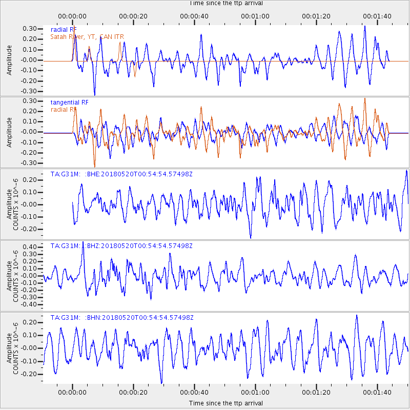
G31M Satah River, YT, CAN - Earthquake Result Viewer
*The percent match for this event was below the threshold and hence no stack was calculated.
| Earthquake location: |
Tonga Islands |
| Earthquake latitude/longitude: |
-21.0/-174.0 |
| Earthquake time(UTC): |
2018/05/20 (140) 00:42:14 GMT |
| Earthquake Depth: |
10 km |
| Earthquake Magnitude: |
5.5 Mww |
| Earthquake Catalog/Contributor: |
NEIC PDE/us |
|
| Network: |
TA USArray Transportable Network (new EarthScope stations) |
| Station: |
G31M Satah River, YT, CAN |
| Lat/Lon: |
66.92 N/134.27 W |
| Elevation: |
61 m |
|
| Distance: |
92.5 deg |
| Az: |
14.608 deg |
| Baz: |
216.72 deg |
| Ray Param: |
$rayparam |
*The percent match for this event was below the threshold and hence was not used in the summary stack. |
|
| Radial Match: |
61.621048 % |
| Radial Bump: |
400 |
| Transverse Match: |
46.465023 % |
| Transverse Bump: |
400 |
| SOD ConfigId: |
13570011 |
| Insert Time: |
2019-04-30 07:05:54.679 +0000 |
| GWidth: |
2.5 |
| Max Bumps: |
400 |
| Tol: |
0.001 |
|
Signal To Noise
| Channel | StoN | STA | LTA |
| TA:G31M: :BHZ:20180520T00:54:54.57498Z | 2.0853367 | 1.6564259E-7 | 7.943206E-8 |
| TA:G31M: :BHN:20180520T00:54:54.57498Z | 0.8649268 | 9.145818E-8 | 1.0574095E-7 |
| TA:G31M: :BHE:20180520T00:54:54.57498Z | 0.90785265 | 6.7073266E-8 | 7.3881225E-8 |
| Arrivals |
| Ps | |
| PpPs | |
| PsPs/PpSs | |


