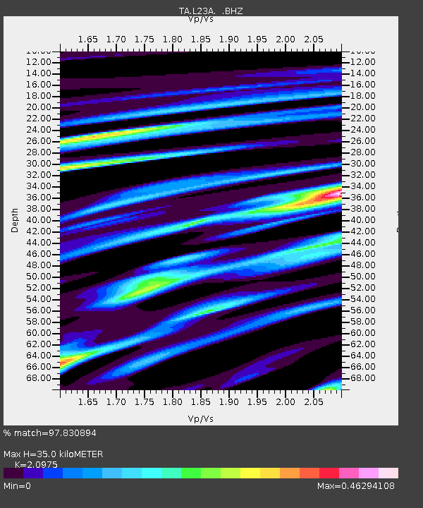
L23A Garrett, WY, USA - Earthquake Result Viewer

Earthquake location: Off East Coast Of Honshu, Japan
Earthquake latitude/longitude: 37.6/142.2
Earthquake time(UTC): 2008/07/19 (201) 02:39:28 GMT
Earthquake Depth: 22 km
Earthquake Magnitude: 6.2 MB, 7.0 MS, 7.0 MW, 6.9 MW
Earthquake Catalog/Contributor: WHDF/NEIC
Network: TA USArray Transportable Network (new EarthScope stations)
Station: L23A Garrett, WY, USA
Lat/Lon: 42.11 N/105.70 W
Elevation: 2153 m
Distance: 79.4 deg
Az: 44.533 deg
Baz: 311.485 deg
Ray Param: 0.048932735
Estimated Moho Depth: 35.0 km
Estimated Crust Vp/Vs: 2.10
Assumed Crust Vp: 6.159 km/s
Estimated Crust Vs: 2.936 km/s
Estimated Crust Poisson's Ratio: 0.35
Radial Match: 97.830894 %
Radial Bump: 234
Transverse Match: 88.390465 %
Transverse Bump: 400
SOD ConfigId: 2504
Insert Time: 2010-03-06 11:21:19.384 +0000
GWidth: 2.5
Max Bumps: 400
Tol: 0.001

Signal To Noise

ChannelStoNSTALTA
TA:L23A: :BHZ:20080719T02:51:01.923999Z7.7843316.0704775E-77.7983294E-8
TA:L23A: :BHN:20080719T02:51:01.923999Z4.512112.006371E-74.4466358E-8
TA:L23A: :BHE:20080719T02:51:01.923999Z4.818821.557926E-73.2330032E-8
Arrivals
Ps6.4 SECOND
PpPs17 SECOND
PsPs/PpSs24 SECOND