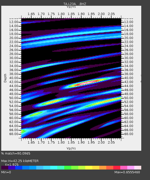
L23A Garrett, WY, USA - Earthquake Result Viewer

Earthquake location: Rat Islands, Aleutian Islands
Earthquake latitude/longitude: 51.3/179.0
Earthquake time(UTC): 2008/07/25 (207) 00:29:22 GMT
Earthquake Depth: 21 km
Earthquake Magnitude: 5.7 MB, 5.5 MS, 5.9 MW, 5.9 MW
Earthquake Catalog/Contributor: WHDF/NEIC
Network: TA USArray Transportable Network (new EarthScope stations)
Station: L23A Garrett, WY, USA
Lat/Lon: 42.11 N/105.70 W
Elevation: 2153 m
Distance: 50.3 deg
Az: 69.236 deg
Baz: 307.878 deg
Ray Param: 0.06810056
Estimated Moho Depth: 42.25 km
Estimated Crust Vp/Vs: 1.92
Assumed Crust Vp: 6.159 km/s
Estimated Crust Vs: 3.199 km/s
Estimated Crust Poisson's Ratio: 0.32
Radial Match: 90.0965 %
Radial Bump: 367
Transverse Match: 54.19586 %
Transverse Bump: 400
SOD ConfigId: 2504
Insert Time: 2010-03-06 11:21:24.486 +0000
GWidth: 2.5
Max Bumps: 400
Tol: 0.001

Signal To Noise

ChannelStoNSTALTA
TA:L23A: :BHZ:20080725T00:37:47.273986Z9.7292845.607817E-75.7638537E-8
TA:L23A: :BHN:20080725T00:37:47.273986Z4.8790952.4732057E-75.0689845E-8
TA:L23A: :BHE:20080725T00:37:47.273986Z6.12641332.1715803E-73.5446195E-8
Arrivals
Ps6.7 SECOND
PpPs19 SECOND
PsPs/PpSs26 SECOND