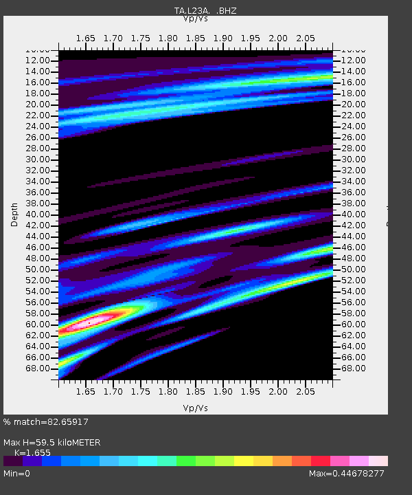
L23A Garrett, WY, USA - Earthquake Result Viewer

Earthquake location: Andreanof Islands, Aleutian Is.
Earthquake latitude/longitude: 52.2/-175.7
Earthquake time(UTC): 2008/08/07 (220) 18:30:03 GMT
Earthquake Depth: 12 km
Earthquake Magnitude: 5.6 MB, 5.5 MS, 5.8 MW, 5.8 MW
Earthquake Catalog/Contributor: WHDF/NEIC
Network: TA USArray Transportable Network (new EarthScope stations)
Station: L23A Garrett, WY, USA
Lat/Lon: 42.11 N/105.70 W
Elevation: 2153 m
Distance: 46.9 deg
Az: 73.256 deg
Baz: 307.598 deg
Ray Param: 0.0703576
Estimated Moho Depth: 59.5 km
Estimated Crust Vp/Vs: 1.65
Assumed Crust Vp: 6.159 km/s
Estimated Crust Vs: 3.721 km/s
Estimated Crust Poisson's Ratio: 0.21
Radial Match: 82.65917 %
Radial Bump: 400
Transverse Match: 46.540237 %
Transverse Bump: 400
SOD ConfigId: 2504
Insert Time: 2010-03-06 11:21:25.707 +0000
GWidth: 2.5
Max Bumps: 400
Tol: 0.001

Signal To Noise

ChannelStoNSTALTA
TA:L23A: :BHZ:20080807T18:38:02.098992Z15.4093276.521802E-74.232373E-8
TA:L23A: :BHN:20080807T18:38:02.098992Z3.00367832.634531E-78.7710156E-8
TA:L23A: :BHE:20080807T18:38:02.098992Z3.6443052.865123E-77.861918E-8
Arrivals
Ps6.7 SECOND
PpPs24 SECOND
PsPs/PpSs31 SECOND