You are here: Home > Network List > TA - USArray Transportable Network (new EarthScope stations) Stations List
> Station L23A Garrett, WY, USA > Earthquake Result Viewer
L23A Garrett, WY, USA - Earthquake Result Viewer

| Earthquake location: |
Hokkaido, Japan Region |
| Earthquake latitude/longitude: |
41.9/143.8 |
| Earthquake time(UTC): |
2008/09/11 (255) 00:20:50 GMT |
| Earthquake Depth: |
25 km |
| Earthquake Magnitude: |
6.1 MB, 7.0 MS, 6.8 MW, 6.8 MW |
| Earthquake Catalog/Contributor: |
WHDF/NEIC |
|
| Network: |
TA USArray Transportable Network (new EarthScope stations) |
| Station: |
L23A Garrett, WY, USA |
| Lat/Lon: |
42.11 N/105.70 W |
| Elevation: |
2153 m |
|
| Distance: |
75.6 deg |
| Az: |
46.011 deg |
| Baz: |
313.782 deg |
| Ray Param: |
0.051562473 |
| Estimated Moho Depth: |
58.25 km |
| Estimated Crust Vp/Vs: |
1.72 |
| Assumed Crust Vp: |
6.159 km/s |
| Estimated Crust Vs: |
3.591 km/s |
| Estimated Crust Poisson's Ratio: |
0.24 |
|
| Radial Match: |
88.284096 % |
| Radial Bump: |
305 |
| Transverse Match: |
78.9095 % |
| Transverse Bump: |
400 |
| SOD ConfigId: |
2560 |
| Insert Time: |
2010-03-06 11:21:44.758 +0000 |
| GWidth: |
2.5 |
| Max Bumps: |
400 |
| Tol: |
0.001 |
|
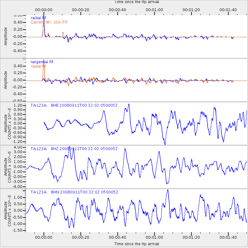
Signal To Noise
| Channel | StoN | STA | LTA |
| TA:L23A: :BHZ:20080911T00:32:02.050005Z | 4.0481415 | 1.0167329E-6 | 2.511604E-7 |
| TA:L23A: :BHN:20080911T00:32:02.050005Z | 1.7547482 | 4.5391238E-7 | 2.5867664E-7 |
| TA:L23A: :BHE:20080911T00:32:02.050005Z | 2.4789908 | 4.4682668E-7 | 1.8024541E-7 |
| Arrivals |
| Ps | 7.0 SECOND |
| PpPs | 25 SECOND |
| PsPs/PpSs | 32 SECOND |


