You are here: Home > Network List > TA - USArray Transportable Network (new EarthScope stations) Stations List
> Station L23A Garrett, WY, USA > Earthquake Result Viewer
L23A Garrett, WY, USA - Earthquake Result Viewer
| Earthquake location: |
Colombia |
| Earthquake latitude/longitude: |
4.8/-75.5 |
| Earthquake time(UTC): |
2008/09/13 (257) 09:32:01 GMT |
| Earthquake Depth: |
133 km |
| Earthquake Magnitude: |
5.9 MB, 5.7 MW, 5.7 MW |
| Earthquake Catalog/Contributor: |
WHDF/NEIC |
|
| Network: |
TA USArray Transportable Network (new EarthScope stations) |
| Station: |
L23A Garrett, WY, USA |
| Lat/Lon: |
42.11 N/105.70 W |
| Elevation: |
2153 m |
|
| Distance: |
45.9 deg |
| Az: |
328.584 deg |
| Baz: |
135.722 deg |
| Ray Param: |
0.07054243 |
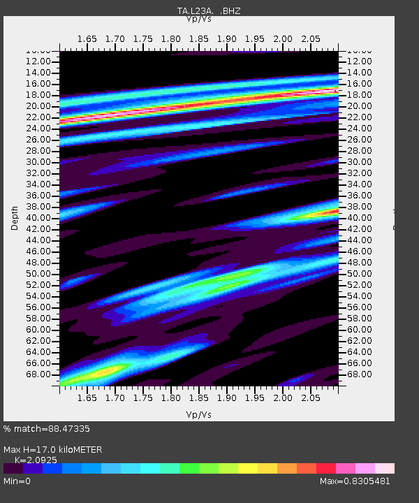
| Estimated Moho Depth: |
17.0 km |
| Estimated Crust Vp/Vs: |
2.09 |
| Assumed Crust Vp: |
6.159 km/s |
| Estimated Crust Vs: |
2.943 km/s |
| Estimated Crust Poisson's Ratio: |
0.35 |
|
| Radial Match: |
88.47335 % |
| Radial Bump: |
400 |
| Transverse Match: |
63.582973 % |
| Transverse Bump: |
382 |
| SOD ConfigId: |
2560 |
| Insert Time: |
2010-03-06 11:21:45.925 +0000 |
| GWidth: |
2.5 |
| Max Bumps: |
400 |
| Tol: |
0.001 |
|

Signal To Noise
| Channel | StoN | STA | LTA |
| TA:L23A: :BHZ:20080913T09:39:39.92399Z | 7.1632595 | 1.6344134E-6 | 2.2816616E-7 |
| TA:L23A: :BHN:20080913T09:39:39.92399Z | 5.2442656 | 6.526012E-7 | 1.2444092E-7 |
| TA:L23A: :BHE:20080913T09:39:39.92399Z | 8.545764 | 7.084489E-7 | 8.29006E-8 |
| Arrivals |
| Ps | 3.2 SECOND |
| PpPs | 8.1 SECOND |
| PsPs/PpSs | 11 SECOND |


